Gamberale geodata
Gamberale (Abruzzo) is a seat of a third-order administrative division; located in Italy in Europe/Rome (GMT+2) time zone. With population of 112 people, there are 11400 cities with bigger population in this country. Compared to other cities in Italy, 71.2% of cities are located further ↑North; 79.9% of cities are located further ←West and 99.2% of cities have lower elevation than Gamberale. Note1


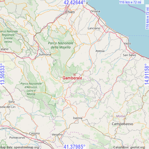
Gamberale GPS coordinates[2]
41° 54' 19.044" North, 14° 12' 30.42" East
| Map corner | latitude | longitude |
|---|---|---|
| Upper-left | 42.42644°, | 13.50533° |
| Center: | 41.90529°, | 14.20845° |
| Lower-right: | 41.37985°, | 14.91158° |
| Map W x H: | 116.4×116.4 km | = 72.3×72.3mi |
| max Lat: | 47.04031° ⇑71.2% North |
| Gamberale: | 41.90529° |
| min Lat: | ⇓28.8% South 35.50142° |
| min Long | Gamberale | max Long |
| 6.69888° | 14.20845° | 18.48682° |
| W 79.9%⇐ | ⇒20.1% E |
Elevation
Elevation of Gamberale is 1318 m = 4324 ft, and this is 1011.3 m = 3318 ft above average elevation for this country.
| Max E: |
2085 m = 6841 ft | 0.8% |
| Gamberale | 1318 m 4324 ft | |
| Avg. | 306.7 m = 1006 ft | |
Min E: |
-4 m = -13 ft | 99.2% |
See also: Italy elevation on elevation.city.
Geographical zone
Gamberale is located in North temperate zone (between Tropic of Cancer and the Arctic Circle). Distance of this Northern Tropic circle is 2053.5 km =1276 mi to South.| Distance of | km | miles | from Gamberale |
|---|---|---|---|
| North Pole | 5347.6 | 3322.8 | to North |
| Arctic Circle | 2741.7 | 1703.6 | to North |
| Tropic Cancer | 2053.5 | 1276 | to South |
| Equator | 4659.4 | 2895.2 | to South |


Nearby cities:
15 places around Gamberale: (largest is in red/bold)
• Ateleta
5.7 km =3.5 mi,  188°
188°
• Borrello
8.1 km =5 mi,  80°
80°
• Capracotta
9.3 km =5.8 mi,  149°
149°
• Castel del Giudice
5.9 km =3.7 mi,  161°
161°
• Civitaluparella
8.9 km =5.5 mi,  60°
60°
• Colledimacine
11 km =6.8 mi,  356°
356°
• Fallo
10.2 km =6.3 mi,  68°
68°
• Lettopalena
11.6 km =7.2 mi,  338°
338°
• Montenerodomo
8.7 km =5.4 mi,  24°
24°
• Palena
10.5 km =6.5 mi,  325°
325°
• Pescopennataro
7.7 km =4.8 mi,  113°
113°
• Pizzoferrato
3 km =1.9 mi,  50°
50°
• Quadri
6.9 km =4.3 mi, 72°
• Rosello
11.7 km =7.3 mi,  92°
92°
• Sant'Angelo del Pesco
4.5 km =2.8 mi,  124°
124°
Sources, notices
• [Note1] Compared only with cities in Italy existing in our database
• [Src1] Map data: © OpenStreetMap contributors (CC-BY-SA)
• [Src2] Other city data from geonames.org with taken over terms of usage.
• [Src3] Geographical zone / Annual Mean Temperature by Robert A. Rohde @ Wikipedia
