Roccamandolfi geodata
Roccamandolfi (Molise) is a seat of a third-order administrative division; located in Italy in Europe/Rome (GMT+2) time zone. With population of 913 people, there are 7079 cities with bigger population in this country. Compared to other cities in Italy, 74.9% of cities are located further ↑North; 81.3% of cities are located further ←West and 92.8% of cities have lower elevation than Roccamandolfi. Note1


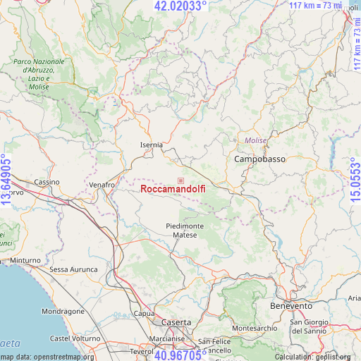
Roccamandolfi GPS coordinates[2]
41° 29' 44.988" North, 14° 21' 7.812" East
| Map corner | latitude | longitude |
|---|---|---|
| Upper-left | 42.02033°, | 13.64905° |
| Center: | 41.49583°, | 14.35217° |
| Lower-right: | 40.96705°, | 15.0553° |
| Map W x H: | 117.1×117.1 km | = 72.8×72.8mi |
| max Lat: | 47.04031° ⇑74.9% North |
| Roccamandolfi: | 41.49583° |
| min Lat: | ⇓25.1% South 35.50142° |
| min Long | Roccamandolfi | max Long |
| 6.69888° | 14.35217° | 18.48682° |
| W 81.3%⇐ | ⇒18.7% E |
Elevation
Elevation of Roccamandolfi is 793 m = 2602 ft, and this is 486.3 m = 1595 ft above average elevation for this country.
| Max E: |
2085 m = 6841 ft | 7.2% |
| Roccamandolfi | 793 m 2602 ft | |
| Avg. | 306.7 m = 1006 ft | |
Min E: |
-4 m = -13 ft | 92.8% |
See also: Italy elevation on elevation.city.
Geographical zone
Roccamandolfi is located in North temperate zone (between Tropic of Cancer and the Arctic Circle). Distance of this Northern Tropic circle is 2008 km =1247.7 mi to South.| Distance of | km | miles | from Roccamandolfi |
|---|---|---|---|
| North Pole | 5393.2 | 3351.2 | to North |
| Arctic Circle | 2787.3 | 1731.9 | to North |
| Tropic Cancer | 2008 | 1247.7 | to South |
| Equator | 4613.9 | 2866.9 | to South |


Nearby cities:
15 places around Roccamandolfi: (largest is in red/bold)
• Bojano
9.9 km =6.2 mi,  96°
96°
• Cantalupo nel Sannio
4.5 km =2.8 mi,  49°
49°
• Carpinone
10.7 km =6.6 mi,  347°
347°
• Castelpetroso
7.2 km =4.5 mi,  356°
356°
• Castelpizzuto
5.8 km =3.6 mi,  299°
299°
• Gallo
11.1 km =6.9 mi,  252°
252°
• Gallo Matese
11.1 km =6.9 mi, 251°
• Indiprete
5.7 km =3.5 mi, 349°
• Letino
9.4 km =5.8 mi,  239°
239°
• Longano
9.3 km =5.8 mi,  288°
288°
• Macchiagodena
8.5 km =5.3 mi,  34°
34°
• Monteverde
11.1 km =6.9 mi,  88°
88°
• Pettoranello del Molise
10.6 km =6.6 mi,  324°
324°
• San Massimo
4.8 km =3 mi, 93°
• Santa Maria del Molise
6.5 km =4 mi,  11°
11°
Sources, notices
• [Note1] Compared only with cities in Italy existing in our database
• [Src1] Map data: © OpenStreetMap contributors (CC-BY-SA)
• [Src2] Other city data from geonames.org with taken over terms of usage.
• [Src3] Geographical zone / Annual Mean Temperature by Robert A. Rohde @ Wikipedia
