Bojano geodata
Bojano (Molise) is a seat of a third-order administrative division; located in Italy in Europe/Rome (GMT+2) time zone. With population of 6,014 people, there are 1635 cities with bigger population in this country. Compared to other cities in Italy, 74.9% of cities are located further ↑North; 82.4% of cities are located further ←West and 77.4% of cities have lower elevation than Bojano. Note1


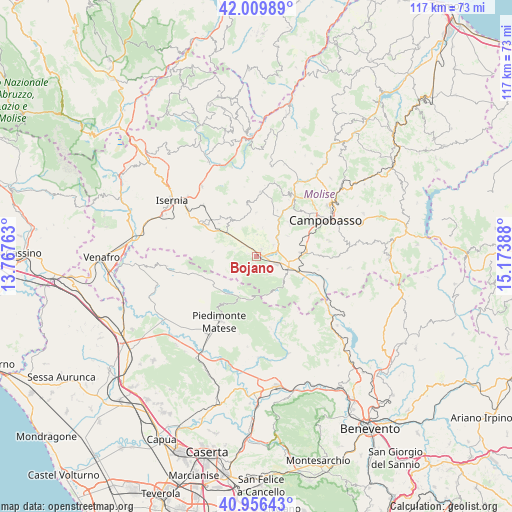
Bojano GPS coordinates[2]
41° 29' 7.08" North, 14° 28' 14.7" East
| Map corner | latitude | longitude |
|---|---|---|
| Upper-left | 42.00989°, | 13.76763° |
| Center: | 41.4853°, | 14.47075° |
| Lower-right: | 40.95643°, | 15.17388° |
| Map W x H: | 117.1×117.1 km | = 72.8×72.8mi |
| max Lat: | 47.04031° ⇑74.9% North |
| Bojano: | 41.4853° |
| min Lat: | ⇓25.1% South 35.50142° |
| min Long | Bojano | max Long |
| 6.69888° | 14.47075° | 18.48682° |
| W 82.4%⇐ | ⇒17.6% E |
Elevation
Elevation of Bojano is 485 m = 1591 ft, and this is 178.3 m = 585 ft above average elevation for this country.
| Max E: |
2085 m = 6841 ft | 22.6% |
| Bojano | 485 m 1591 ft | |
| Avg. | 306.7 m = 1006 ft | |
Min E: |
-4 m = -13 ft | 77.4% |
See also: Italy elevation on elevation.city.
Geographical zone
Bojano is located in North temperate zone (between Tropic of Cancer and the Arctic Circle). Distance of this Northern Tropic circle is 2006.8 km =1247 mi to South.| Distance of | km | miles | from Bojano |
|---|---|---|---|
| North Pole | 5394.3 | 3351.9 | to North |
| Arctic Circle | 2788.4 | 1732.6 | to North |
| Tropic Cancer | 2006.8 | 1247 | to South |
| Equator | 4612.7 | 2866.2 | to South |


Nearby cities:
15 places around Bojano: (largest is in red/bold)
• Baranello
8.6 km =5.3 mi,  57°
57°
• Busso
10.7 km =6.6 mi,  44°
44°
• Campochiaro
5.2 km =3.2 mi,  142°
142°
• Cantalupo nel Sannio
7.6 km =4.7 mi,  302°
302°
• Colle d'Anchise
4.8 km =3 mi, 55°
• Guardiaregia
8.3 km =5.2 mi,  133°
133°
• Largo Zullo-Sterparo
10.7 km =6.6 mi,  69°
69°
• Macchiagodena
9.6 km =6 mi,  328°
328°
• Monteverde
2 km =1.2 mi, 39°
• Roccamandolfi
9.9 km =6.2 mi,  276°
276°
• San Massimo
5.1 km =3.2 mi, 279°
• San Polomatese
3.5 km =2.2 mi,  146°
146°
• Sant'Elena Sannita
10 km =6.2 mi,  359°
359°
• Spinete
6.7 km =4.2 mi,  11°
11°
• Vinchiaturo
10.1 km =6.3 mi,  85°
85°
Sources, notices
• [Note1] Compared only with cities in Italy existing in our database
• [Src1] Map data: © OpenStreetMap contributors (CC-BY-SA)
• [Src2] Other city data from geonames.org with taken over terms of usage.
• [Src3] Geographical zone / Annual Mean Temperature by Robert A. Rohde @ Wikipedia
