Monteverde geodata
Monteverde (Molise) is a populated place; located in Italy in Europe/Rome (GMT+2) time zone. With population of 766 people, there are 7842 cities with bigger population in this country. Compared to other cities in Italy, 74.8% of cities are located further ↑North; 82.5% of cities are located further ←West and 77.5% of cities have lower elevation than Monteverde. Note1


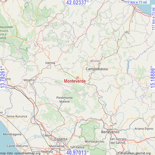
Monteverde GPS coordinates[2]
41° 29' 56.004" North, 14° 29' 8.628" East
| Map corner | latitude | longitude |
|---|---|---|
| Upper-left | 42.02337°, | 13.78261° |
| Center: | 41.49889°, | 14.48573° |
| Lower-right: | 40.97013°, | 15.18886° |
| Map W x H: | 117.1×117.1 km | = 72.8×72.8mi |
| max Lat: | 47.04031° ⇑74.8% North |
| Monteverde: | 41.49889° |
| min Lat: | ⇓25.2% South 35.50142° |
| min Long | Monteverde | max Long |
| 6.69888° | 14.48573° | 18.48682° |
| W 82.5%⇐ | ⇒17.5% E |
Elevation
Elevation of Monteverde is 486 m = 1594 ft, and this is 179.3 m = 588 ft above average elevation for this country.
| Max E: |
2085 m = 6841 ft | 22.5% |
| Monteverde | 486 m 1594 ft | |
| Avg. | 306.7 m = 1006 ft | |
Min E: |
-4 m = -13 ft | 77.5% |
See also: Italy elevation on elevation.city.
Geographical zone
Monteverde is located in North temperate zone (between Tropic of Cancer and the Arctic Circle). Distance of this Northern Tropic circle is 2008.3 km =1247.9 mi to South.| Distance of | km | miles | from Monteverde |
|---|---|---|---|
| North Pole | 5392.8 | 3350.9 | to North |
| Arctic Circle | 2786.9 | 1731.7 | to North |
| Tropic Cancer | 2008.3 | 1247.9 | to South |
| Equator | 4614.2 | 2867.1 | to South |


Nearby cities:
15 places around Monteverde: (largest is in red/bold)
• Baranello
6.8 km =4.2 mi,  62°
62°
• Bojano
2 km =1.2 mi,  219°
219°
• Busso
8.8 km =5.5 mi,  45°
45°
• Campochiaro
5.9 km =3.7 mi,  161°
161°
• Cantalupo nel Sannio
8.1 km =5 mi,  288°
288°
• Casalciprano
9.7 km =6 mi,  21°
21°
• Colle d'Anchise
3 km =1.9 mi,  66°
66°
• Guardiaregia
8.6 km =5.3 mi,  146°
146°
• Largo Zullo-Sterparo
9 km =5.6 mi,  75°
75°
• Macchiagodena
9.2 km =5.7 mi,  316°
316°
• San Massimo
6.3 km =3.9 mi,  263°
263°
• San Polomatese
4.4 km =2.7 mi,  171°
171°
• Sant'Elena Sannita
8.6 km =5.3 mi,  351°
351°
• Spinete
5.1 km =3.2 mi,  1°
1°
• Vinchiaturo
8.9 km =5.5 mi,  94°
94°
Sources, notices
• [Note1] Compared only with cities in Italy existing in our database
• [Src1] Map data: © OpenStreetMap contributors (CC-BY-SA)
• [Src2] Other city data from geonames.org with taken over terms of usage.
• [Src3] Geographical zone / Annual Mean Temperature by Robert A. Rohde @ Wikipedia
