Ro geodata
Ro (Emilia-Romagna) is a seat of a third-order administrative division; located in Italy in Europe/Rome (GMT+2) time zone. With population of 1,473 people, there are 5187 cities with bigger population in this country. Compared to other cities in Italy, 58.8% of cities are located further ↓South; 52.6% of cities are located further ←West and 97.2% of cities have higher elevation than Ro. Note1
Administrative division(s):
- Level 1: Emilia-Romagna
- Level 2: Provincia di Ferrara
- Level 3: Riva del Po


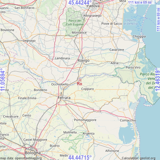
Ro GPS coordinates[2]
44° 56' 49.02" North, 11° 45' 36.216" East
| Map corner | latitude | longitude |
|---|---|---|
| Upper-left | 45.44244°, | 11.05694° |
| Center: | 44.94695°, | 11.76006° |
| Lower-right: | 44.44715°, | 12.46319° |
| Map W x H: | 110.7×110.7 km | = 68.8×68.8mi |
| max Lat: | 47.04031° ⇑41.2% North |
| Ro: | 44.94695° |
| min Lat: | ⇓58.8% South 35.50142° |
| min Long | Ro | max Long |
| 6.69888° | 11.76006° | 18.48682° |
| W 52.6%⇐ | ⇒47.4% E |
Elevation
Elevation of Ro is 5 m = 16 ft, and this is 301.7 m = 990 ft below average elevation for this country.
| Max E: |
2085 m = 6841 ft | 97.2% |
| Avg. | 306.7 m = 1006 ft | |
| Ro | 5 m = 16 ft | |
Min E: |
-4 m = -13 ft | 2.8% |
See also: Italy elevation on elevation.city.
Geographical zone
Ro is located in North temperate zone (between Tropic of Cancer and the Arctic Circle). Distance of this Northern Tropic circle is 2391.7 km =1486.1 mi to South.| Distance of | km | miles | from Ro |
|---|---|---|---|
| North Pole | 5009.4 | 3112.7 | to North |
| Arctic Circle | 2403.5 | 1493.5 | to North |
| Tropic Cancer | 2391.7 | 1486.1 | to South |
| Equator | 4997.6 | 3105.4 | to South |


Nearby cities:
15 places around Ro: (largest is in red/bold)
• Alberone
5.6 km =3.5 mi,  69°
69°
• Arquà Polesine
7.2 km =4.5 mi,  347°
347°
• Bosaro
5.8 km =3.6 mi,  3°
3°
• Canaro
6.8 km =4.2 mi,  257°
257°
• Coccanile-Cesta
9 km =5.6 mi,  111°
111°
• Cologna
10.9 km =6.8 mi,  77°
77°
• Copparo
7.8 km =4.8 mi,  140°
140°
• Francolino
9.9 km =6.2 mi,  235°
235°
• Frassinelle Polesine
7.2 km =4.5 mi,  318°
318°
• Grignano Polesine
10.8 km =6.7 mi, 354°
• Guarda Veneta
5.1 km =3.2 mi,  40°
40°
• La Saletta-Tamara
7.3 km =4.5 mi,  172°
172°
• Polesella
2.1 km =1.3 mi,  335°
335°
• Pontecchio Polesine
9.2 km =5.7 mi,  27°
27°
• Villamarzana
9.2 km =5.7 mi, 324°
Sources, notices
• [Note1] Compared only with cities in Italy existing in our database
• [Src1] Map data: © OpenStreetMap contributors (CC-BY-SA)
• [Src2] Other city data from geonames.org with taken over terms of usage.
• [Src3] Geographical zone / Annual Mean Temperature by Robert A. Rohde @ Wikipedia
