Copparo geodata
Copparo (Emilia-Romagna) is a seat of a third-order administrative division; located in Italy in Europe/Rome (GMT+2) time zone. With population of 8,903 people, there are 1069 cities with bigger population in this country. Compared to other cities in Italy, 57.8% of cities are located further ↓South; 53.5% of cities are located further ←West and 97.8% of cities have higher elevation than Copparo. Note1


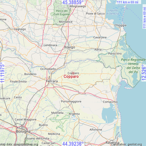
Copparo GPS coordinates[2]
44° 53' 33.468" North, 11° 49' 22.332" East
| Map corner | latitude | longitude |
|---|---|---|
| Upper-left | 45.38859°, | 11.11975° |
| Center: | 44.89263°, | 11.82287° |
| Lower-right: | 44.39236°, | 12.526° |
| Map W x H: | 110.8×110.8 km | = 68.8×68.8mi |
| max Lat: | 47.04031° ⇑42.2% North |
| Copparo: | 44.89263° |
| min Lat: | ⇓57.8% South 35.50142° |
| min Long | Copparo | max Long |
| 6.69888° | 11.82287° | 18.48682° |
| W 53.5%⇐ | ⇒46.5% E |
Elevation
Elevation of Copparo is 4 m = 13 ft, and this is 302.7 m = 993 ft below average elevation for this country.
| Max E: |
2085 m = 6841 ft | 97.8% |
| Avg. | 306.7 m = 1006 ft | |
| Copparo | 4 m = 13 ft | |
Min E: |
-4 m = -13 ft | 2.2% |
See also: Italy elevation on elevation.city.
Geographical zone
Copparo is located in North temperate zone (between Tropic of Cancer and the Arctic Circle). Distance of this Northern Tropic circle is 2385.7 km =1482.4 mi to South.| Distance of | km | miles | from Copparo |
|---|---|---|---|
| North Pole | 5015.5 | 3116.5 | to North |
| Arctic Circle | 2409.6 | 1497.3 | to North |
| Tropic Cancer | 2385.7 | 1482.4 | to South |
| Equator | 4991.6 | 3101.6 | to South |


Nearby cities:
15 places around Copparo: (largest is in red/bold)
• Alberone
8 km =5 mi,  2°
2°
• Ambrogio
7.3 km =4.5 mi,  73°
73°
• Baura
9.4 km =5.8 mi,  241°
241°
• Boara
11.3 km =7 mi,  253°
253°
• Coccanile-Cesta
4.4 km =2.7 mi,  52°
52°
• Cologna
10.2 km =6.3 mi,  33°
33°
• Crespino
11.6 km =7.2 mi, 27°
• Formignana
6.3 km =3.9 mi,  152°
152°
• Guarda Veneta
10.1 km =6.3 mi,  350°
350°
• La Saletta-Tamara
4.2 km =2.6 mi, 252°
• Masi-Torello
11 km =6.8 mi,  188°
188°
• Polesella
9.9 km =6.2 mi,  323°
323°
• Quartesana
11.8 km =7.3 mi,  214°
214°
• Ro
7.8 km =4.8 mi, 320°
• Tresigallo-Final di Rero
10.2 km =6.3 mi, 146°
Sources, notices
• [Note1] Compared only with cities in Italy existing in our database
• [Src1] Map data: © OpenStreetMap contributors (CC-BY-SA)
• [Src2] Other city data from geonames.org with taken over terms of usage.
• [Src3] Geographical zone / Annual Mean Temperature by Robert A. Rohde @ Wikipedia
