La Saletta-Tamara geodata
La Saletta-Tamara (Emilia-Romagna) is a populated place; located in Italy in Europe/Rome (GMT+2) time zone. With population of 1,469 people, there are 5201 cities with bigger population in this country. Compared to other cities in Italy, 57.6% of cities are located further ↓South; 52.7% of cities are located further ←West and 99% of cities have higher elevation than La Saletta-Tamara. Note1


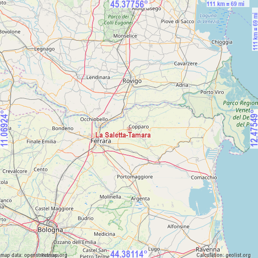
La Saletta-Tamara GPS coordinates[2]
44° 52' 53.436" North, 11° 46' 20.496" East
| Map corner | latitude | longitude |
|---|---|---|
| Upper-left | 45.37756°, | 11.06924° |
| Center: | 44.88151°, | 11.77236° |
| Lower-right: | 44.38114°, | 12.47549° |
| Map W x H: | 110.8×110.8 km | = 68.8×68.8mi |
| max Lat: | 47.04031° ⇑42.4% North |
| La Saletta-Tamara: | 44.88151° |
| min Lat: | ⇓57.6% South 35.50142° |
| min Long | La Saletta-Tama | max Long |
| 6.69888° | 11.77236° | 18.48682° |
| W 52.7%⇐ | ⇒47.3% E |
Elevation
Elevation of La Saletta-Tamara is 2 m = 7 ft, and this is 304.7 m = 1000 ft below average elevation for this country.
| Max E: |
2085 m = 6841 ft | 99% |
| Avg. | 306.7 m = 1006 ft | |
| La Saletta-Tamara | 2 m = 7 ft | |
Min E: |
-4 m = -13 ft | 1% |
See also: Italy elevation on elevation.city.
Geographical zone
La Saletta-Tamara is located in North temperate zone (between Tropic of Cancer and the Arctic Circle). Distance of this Northern Tropic circle is 2384.4 km =1481.6 mi to South.| Distance of | km | miles | from La Saletta-Tamara |
|---|---|---|---|
| North Pole | 5016.7 | 3117.2 | to North |
| Arctic Circle | 2410.8 | 1498 | to North |
| Tropic Cancer | 2384.4 | 1481.6 | to South |
| Equator | 4990.4 | 3100.9 | to South |


Nearby cities:
15 places around La Saletta-Tamara: (largest is in red/bold)
• Alberone
10.2 km =6.3 mi,  25°
25°
• Baura
5.4 km =3.4 mi,  232°
232°
• Boara
7.1 km =4.4 mi,  253°
253°
• Canaro
9.6 km =6 mi,  307°
307°
• Coccanile-Cesta
8.4 km =5.2 mi,  62°
62°
• Cona
9.9 km =6.2 mi,  211°
211°
• Copparo
4.2 km =2.6 mi,  72°
72°
• Formignana
8.1 km =5 mi,  122°
122°
• Francolino
9.2 km =5.7 mi,  280°
280°
• Guarda Veneta
11.4 km =7.1 mi,  11°
11°
• Masi-Torello
9.9 km =6.2 mi,  166°
166°
• Polesella
9.4 km =5.8 mi,  348°
348°
• Pontegradella
9.9 km =6.2 mi,  240°
240°
• Quartesana
8.9 km =5.5 mi,  197°
197°
• Ro
7.3 km =4.5 mi, 352°
Sources, notices
• [Note1] Compared only with cities in Italy existing in our database
• [Src1] Map data: © OpenStreetMap contributors (CC-BY-SA)
• [Src2] Other city data from geonames.org with taken over terms of usage.
• [Src3] Geographical zone / Annual Mean Temperature by Robert A. Rohde @ Wikipedia
