Melfi geodata
Melfi (Basilicate) is a seat of a third-order administrative division; located in Italy in Europe/Rome (GMT+2) time zone. With population of 13,079 people, there are 703 cities with bigger population in this country. Compared to other cities in Italy, 78.7% of cities are located further ↑North; 91.1% of cities are located further ←West and 80.3% of cities have lower elevation than Melfi. Note1


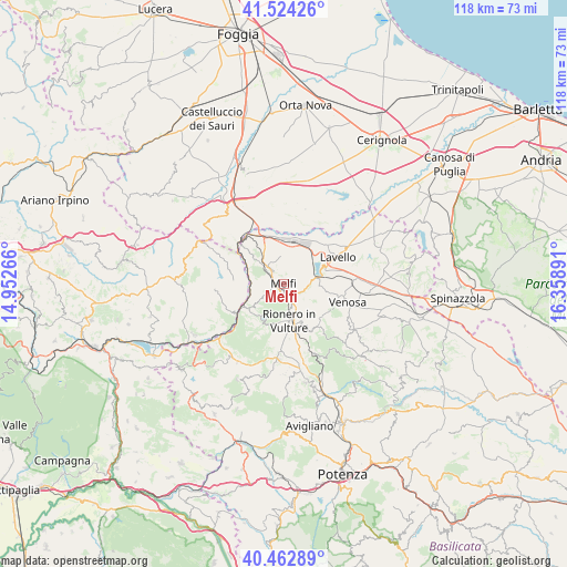
Melfi GPS coordinates[2]
40° 59' 44.556" North, 15° 39' 20.808" East
| Map corner | latitude | longitude |
|---|---|---|
| Upper-left | 41.52426°, | 14.95266° |
| Center: | 40.99571°, | 15.65578° |
| Lower-right: | 40.46289°, | 16.35891° |
| Map W x H: | 118×118 km | = 73.3×73.3mi |
| max Lat: | 47.04031° ⇑78.7% North |
| Melfi: | 40.99571° |
| min Lat: | ⇓21.3% South 35.50142° |
| min Long | Melfi | max Long |
| 6.69888° | 15.65578° | 18.48682° |
| W 91.1%⇐ | ⇒8.9% E |
Elevation
Elevation of Melfi is 529 m = 1736 ft, and this is 222.3 m = 729 ft above average elevation for this country.
| Max E: |
2085 m = 6841 ft | 19.7% |
| Melfi | 529 m 1736 ft | |
| Avg. | 306.7 m = 1006 ft | |
Min E: |
-4 m = -13 ft | 80.3% |
See also: Italy elevation on elevation.city.
Geographical zone
Melfi is located in North temperate zone (between Tropic of Cancer and the Arctic Circle). Distance of this Northern Tropic circle is 1952.4 km =1213.2 mi to South.| Distance of | km | miles | from Melfi |
|---|---|---|---|
| North Pole | 5448.8 | 3385.7 | to North |
| Arctic Circle | 2842.9 | 1766.5 | to North |
| Tropic Cancer | 1952.4 | 1213.2 | to South |
| Equator | 4558.3 | 2832.4 | to South |


Nearby cities:
15 places around Melfi: (largest is in red/bold)
• Aquilonia
15.2 km =9.4 mi,  266°
266°
• Atella
13 km =8.1 mi,  181°
181°
• Barile
6 km =3.7 mi,  167°
167°
• Candela
19.5 km =12.1 mi,  322°
322°
• Ginestra
9.8 km =6.1 mi,  137°
137°
• Lavello
12.6 km =7.8 mi,  62°
62°
• Maschito
17.5 km =10.9 mi,  123°
123°
• Monteverde
10.3 km =6.4 mi, 271°
• Rapolla
2.7 km =1.7 mi,  149°
149°
• Rionero in Vulture
8.2 km =5.1 mi, 170°
• Ripacandida
11 km =6.8 mi, 147°
• Ruvo del Monte
18.9 km =11.7 mi,  210°
210°
• Scalera
16.1 km =10 mi,  160°
160°
• Venosa
13.7 km =8.5 mi,  105°
105°
• Zona 179
3.2 km =2 mi,  284°
284°
Sources, notices
• [Note1] Compared only with cities in Italy existing in our database
• [Src1] Map data: © OpenStreetMap contributors (CC-BY-SA)
• [Src2] Other city data from geonames.org with taken over terms of usage.
• [Src3] Geographical zone / Annual Mean Temperature by Robert A. Rohde @ Wikipedia
