Ravenna geodata
Ravenna (Emilia-Romagna) is a seat of a second-order administrative division; located in Italy in Europe/Rome (GMT+2) time zone. With population of 80,868 people, there are 49 cities with bigger population in this country. Compared to other cities in Italy, 50.2% of cities are located further ↑North; 58.6% of cities are located further ←West and 94.8% of cities have higher elevation than Ravenna. Note1


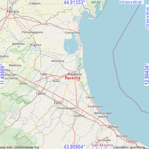
Ravenna GPS coordinates[2]
44° 24' 48.384" North, 12° 12' 4.356" East
| Map corner | latitude | longitude |
|---|---|---|
| Upper-left | 44.91353°, | 11.49809° |
| Center: | 44.41344°, | 12.20121° |
| Lower-right: | 43.90904°, | 12.90434° |
| Map W x H: | 111.7×111.7 km | = 69.4×69.4mi |
| max Lat: | 47.04031° ⇑50.2% North |
| Ravenna: | 44.41344° |
| min Lat: | ⇓49.8% South 35.50142° |
| min Long | Ravenna | max Long |
| 6.69888° | 12.20121° | 18.48682° |
| W 58.6%⇐ | ⇒41.4% E |
Elevation
Elevation of Ravenna is 9 m = 30 ft, and this is 297.7 m = 977 ft below average elevation for this country.
| Max E: |
2085 m = 6841 ft | 94.8% |
| Avg. | 306.7 m = 1006 ft | |
| Ravenna | 9 m = 30 ft | |
Min E: |
-4 m = -13 ft | 5.2% |
See also: Ravenna elevation on elevation.city.
Geographical zone
Ravenna is located in North temperate zone (between Tropic of Cancer and the Arctic Circle). Distance of this Northern Tropic circle is 2332.4 km =1449.3 mi to South.| Distance of | km | miles | from Ravenna |
|---|---|---|---|
| North Pole | 5068.8 | 3149.6 | to North |
| Arctic Circle | 2462.9 | 1530.4 | to North |
| Tropic Cancer | 2332.4 | 1449.3 | to South |
| Equator | 4938.3 | 3068.5 | to South |


Nearby cities:
15 places around Ravenna: (largest is in red/bold)
• Camerlona
7.2 km =4.5 mi,  301°
301°
• Classe
4.7 km =2.9 mi,  143°
143°
• Fornace Zarattini
5.4 km =3.4 mi,  273°
273°
• Fosso Ghiaia
7.7 km =4.8 mi,  146°
146°
• Lido Adriano
8.3 km =5.2 mi,  87°
87°
• Madonna Dell'Albero
3.6 km =2.2 mi,  180°
180°
• Marina di Ravenna
10.3 km =6.4 mi,  37°
37°
• Piangipane
8.8 km =5.5 mi,  276°
276°
• Porto Fuori
4.1 km =2.5 mi,  102°
102°
• Punta Marina
7.8 km =4.8 mi,  65°
65°
• Romea Vecchia
3.7 km =2.3 mi, 137°
• Roncalceci
9.8 km =6.1 mi,  222°
222°
• San Bartolo
6 km =3.7 mi,  196°
196°
• San Michele
7.2 km =4.5 mi,  262°
262°
• Villanova
7.6 km =4.7 mi,  241°
241°
Sources, notices
• [Note1] Compared only with cities in Italy existing in our database
• [Src1] Map data: © OpenStreetMap contributors (CC-BY-SA)
• [Src2] Other city data from geonames.org with taken over terms of usage.
• [Src3] Geographical zone / Annual Mean Temperature by Robert A. Rohde @ Wikipedia
