Roncalceci geodata
Roncalceci (Emilia-Romagna) is a populated place; located in Italy in Europe/Rome (GMT+2) time zone. With population of 655 people, there are 8600 cities with bigger population in this country. Compared to other cities in Italy, 51.3% of cities are located further ↑North; 57.6% of cities are located further ←West and 97.2% of cities have higher elevation than Roncalceci. Note1


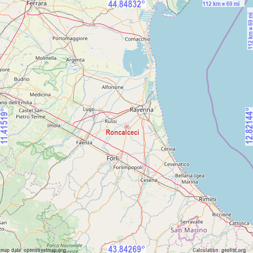
Roncalceci GPS coordinates[2]
44° 20' 51.576" North, 12° 7' 5.916" East
| Map corner | latitude | longitude |
|---|---|---|
| Upper-left | 44.84832°, | 11.41519° |
| Center: | 44.34766°, | 12.11831° |
| Lower-right: | 43.84269°, | 12.82144° |
| Map W x H: | 111.8×111.8 km | = 69.5×69.5mi |
| max Lat: | 47.04031° ⇑51.3% North |
| Roncalceci: | 44.34766° |
| min Lat: | ⇓48.7% South 35.50142° |
| min Long | Roncalceci | max Long |
| 6.69888° | 12.11831° | 18.48682° |
| W 57.6%⇐ | ⇒42.4% E |
Elevation
Elevation of Roncalceci is 5 m = 16 ft, and this is 301.7 m = 990 ft below average elevation for this country.
| Max E: |
2085 m = 6841 ft | 97.2% |
| Avg. | 306.7 m = 1006 ft | |
| Roncalceci | 5 m = 16 ft | |
Min E: |
-4 m = -13 ft | 2.8% |
See also: Italy elevation on elevation.city.
Geographical zone
Roncalceci is located in North temperate zone (between Tropic of Cancer and the Arctic Circle). Distance of this Northern Tropic circle is 2325.1 km =1444.7 mi to South.| Distance of | km | miles | from Roncalceci |
|---|---|---|---|
| North Pole | 5076.1 | 3154.1 | to North |
| Arctic Circle | 2470.2 | 1534.9 | to North |
| Tropic Cancer | 2325.1 | 1444.7 | to South |
| Equator | 4931 | 3064 | to South |


Nearby cities:
15 places around Roncalceci: (largest is in red/bold)
• Campiano
8.3 km =5.2 mi,  130°
130°
• Classe
10 km =6.2 mi,  69°
69°
• Fornace Zarattini
7.8 km =4.8 mi,  8°
8°
• Godo
6 km =3.7 mi,  324°
324°
• Madonna Dell'Albero
7.5 km =4.7 mi,  60°
60°
• Piangipane
8.6 km =5.3 mi,  345°
345°
• Ravenna
9.8 km =6.1 mi,  42°
42°
• Russi
7.5 km =4.7 mi,  295°
295°
• San Bartolo
5.1 km =3.2 mi, 72°
• San Michele
6.4 km =4 mi,  355°
355°
• San Pancrazio
3.4 km =2.1 mi,  290°
290°
• San Pietro In Vincoli
5.7 km =3.5 mi,  157°
157°
• San Pietro in Trento
4.4 km =2.7 mi,  220°
220°
• Santo Stefano-Carraie
6.5 km =4 mi,  123°
123°
• Villanova
3.7 km =2.3 mi, 357°
Sources, notices
• [Note1] Compared only with cities in Italy existing in our database
• [Src1] Map data: © OpenStreetMap contributors (CC-BY-SA)
• [Src2] Other city data from geonames.org with taken over terms of usage.
• [Src3] Geographical zone / Annual Mean Temperature by Robert A. Rohde @ Wikipedia
