Camerlona geodata
Camerlona (Emilia-Romagna) is a populated place; located in Italy in Europe/Rome (GMT+2) time zone. With population of 619 people, there are 8850 cities with bigger population in this country. Compared to other cities in Italy, 50.3% of cities are located further ↓South; 57.6% of cities are located further ←West and 99.4% of cities have higher elevation than Camerlona. Note1


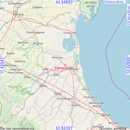
Camerlona GPS coordinates[2]
44° 26' 49.668" North, 12° 7' 24.78" East
| Map corner | latitude | longitude |
|---|---|---|
| Upper-left | 44.94693°, | 11.42043° |
| Center: | 44.44713°, | 12.12355° |
| Lower-right: | 43.94301°, | 12.82668° |
| Map W x H: | 111.6×111.6 km | = 69.3×69.3mi |
| max Lat: | 47.04031° ⇑49.7% North |
| Camerlona: | 44.44713° |
| min Lat: | ⇓50.3% South 35.50142° |
| min Long | Camerlona | max Long |
| 6.69888° | 12.12355° | 18.48682° |
| W 57.6%⇐ | ⇒42.4% E |
Elevation
Elevation of Camerlona is 1 m = 3 ft, and this is 305.7 m = 1003 ft below average elevation for this country.
| Max E: |
2085 m = 6841 ft | 99.4% |
| Avg. | 306.7 m = 1006 ft | |
| Camerlona | 1 m = 3 ft | |
Min E: |
-4 m = -13 ft | 0.6% |
See also: Italy elevation on elevation.city.
Geographical zone
Camerlona is located in North temperate zone (between Tropic of Cancer and the Arctic Circle). Distance of this Northern Tropic circle is 2336.1 km =1451.6 mi to South.| Distance of | km | miles | from Camerlona |
|---|---|---|---|
| North Pole | 5065 | 3147.2 | to North |
| Arctic Circle | 2459.1 | 1528 | to North |
| Tropic Cancer | 2336.1 | 1451.6 | to South |
| Equator | 4942.1 | 3070.9 | to South |


Nearby cities:
15 places around Camerlona: (largest is in red/bold)
• Alfonsine
3.6 km =2.2 mi,  286°
286°
• Alfonsine
9.6 km =6 mi,  314°
314°
• Fornace Zarattini
3.5 km =2.2 mi,  167°
167°
• Glorie
4.5 km =2.8 mi,  304°
304°
• Godo
7.3 km =4.5 mi,  212°
212°
• Madonna Dell'Albero
9.5 km =5.9 mi,  140°
140°
• Mezzano
3.6 km =2.2 mi, 305°
• Piangipane
3.8 km =2.4 mi,  223°
223°
• Ravenna
7.2 km =4.5 mi,  121°
121°
• San Michele
4.8 km =3 mi,  191°
191°
• San Pancrazio
10.5 km =6.5 mi,  199°
199°
• Santerno
5.5 km =3.4 mi,  258°
258°
• Savarna-Conventello
6.8 km =4.2 mi,  348°
348°
• Villanova
5.8 km =3.6 mi,  270°
270°
• Villanova
7.4 km =4.6 mi,  184°
184°
Sources, notices
• [Note1] Compared only with cities in Italy existing in our database
• [Src1] Map data: © OpenStreetMap contributors (CC-BY-SA)
• [Src2] Other city data from geonames.org with taken over terms of usage.
• [Src3] Geographical zone / Annual Mean Temperature by Robert A. Rohde @ Wikipedia
