Carmagnola geodata
Carmagnola (Piedmont) is a seat of a third-order administrative division; located in Italy in Europe/Rome (GMT+2) time zone. With population of 23,012 people, there are 369 cities with bigger population in this country. Compared to other cities in Italy, 57.1% of cities are located further ↓South; 96.2% of cities are located further →East and 50.7% of cities have lower elevation than Carmagnola. Note1


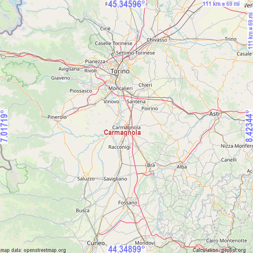
Carmagnola GPS coordinates[2]
44° 50' 58.668" North, 7° 43' 13.152" East
| Map corner | latitude | longitude |
|---|---|---|
| Upper-left | 45.34596°, | 7.01719° |
| Center: | 44.84963°, | 7.72032° |
| Lower-right: | 44.34899°, | 8.42344° |
| Map W x H: | 110.9×110.9 km | = 68.9×68.9mi |
| max Lat: | 47.04031° ⇑42.9% North |
| Carmagnola: | 44.84963° |
| min Lat: | ⇓57.1% South 35.50142° |
| min Long | Carmagnola | max Long |
| 6.69888° | 7.72032° | 18.48682° |
| W 3.8%⇐ | ⇒96.2% E |
Elevation
Elevation of Carmagnola is 239 m = 784 ft, and this is 67.7 m = 222 ft below average elevation for this country.
| Max E: |
2085 m = 6841 ft | 49.3% |
| Avg. | 306.7 m = 1006 ft | |
| Carmagnola | 239 m = 784 ft | |
Min E: |
-4 m = -13 ft | 50.7% |
See also: Italy elevation on elevation.city.
Geographical zone
Carmagnola is located in North temperate zone (between Tropic of Cancer and the Arctic Circle). Distance of this Northern Tropic circle is 2380.9 km =1479.4 mi to South.| Distance of | km | miles | from Carmagnola |
|---|---|---|---|
| North Pole | 5020.3 | 3119.5 | to North |
| Arctic Circle | 2414.4 | 1500.2 | to North |
| Tropic Cancer | 2380.9 | 1479.4 | to South |
| Equator | 4986.8 | 3098.7 | to South |


Nearby cities:
15 places around Carmagnola: (largest is in red/bold)
• Caramagna Piemonte
7.6 km =4.7 mi,  168°
168°
• Carignano
7.3 km =4.5 mi,  328°
328°
• Casalgrasso
8.3 km =5.2 mi,  245°
245°
• Cavalleri-Fumeri
2.6 km =1.6 mi,  136°
136°
• Ceresole Alba
9.8 km =6.1 mi,  124°
124°
• Favari-Avatanei
9.4 km =5.8 mi,  41°
41°
• Lombriasco
6.7 km =4.2 mi,  261°
261°
• Osasio
9.2 km =5.7 mi,  285°
285°
• Pancalieri
10.7 km =6.6 mi, 260°
• Polonghera
11.1 km =6.9 mi,  241°
241°
• Racconigi
9.9 km =6.2 mi,  199°
199°
• San Michele e Grato
1.8 km =1.1 mi,  301°
301°
• Sommariva del Bosco
9.8 km =6.1 mi,  150°
150°
• Tuninetti
4.3 km =2.7 mi,  81°
81°
• Villastellone
8.3 km =5.2 mi,  12°
12°
Sources, notices
• [Note1] Compared only with cities in Italy existing in our database
• [Src1] Map data: © OpenStreetMap contributors (CC-BY-SA)
• [Src2] Other city data from geonames.org with taken over terms of usage.
• [Src3] Geographical zone / Annual Mean Temperature by Robert A. Rohde @ Wikipedia
