San Giovanni del Dosso geodata
San Giovanni del Dosso (Lombardy) is a seat of a third-order administrative division; located in Italy in Europe/Rome (GMT+2) time zone. With population of 864 people, there are 7345 cities with bigger population in this country. Compared to other cities in Italy, 59.3% of cities are located further ↓South; 56.2% of cities are located further →East and 91.5% of cities have higher elevation than San Giovanni del Dosso. Note1
Administrative division(s):
- Level 1: Lombardy
- Level 2: Provincia di Mantova
- Level 3: San Giovanni del Dosso
Current local time in San Giovanni del Dosso:
10:06 PM, WednesdayDifference from your time zone: hours


San Giovanni del Dosso GPS coordinates[2]
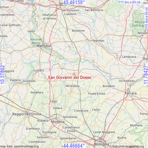
44° 57' 58.572" North, 11° 4' 52.104" East
| Map corner | latitude | longitude |
|---|---|---|
| Upper-left | 45.46159°, | 10.37802° |
| Center: | 44.96627°, | 11.08114° |
| Lower-right: | 44.46664°, | 11.78427° |
| Map W x H: | 110.6×110.6 km | = 68.7×68.7mi |
| max Lat: | 47.04031° ⇑40.7% North |
| San Giovanni del Dosso: | 44.96627° |
| min Lat: | ⇓59.3% South 35.50142° |
| min Long | San Giovanni de | max Long |
| 6.69888° | 11.08114° | 18.48682° |
| W 43.8%⇐ | ⇒56.2% E |
Elevation
Elevation of San Giovanni del Dosso is 15 m = 49 ft, and this is 291.7 m = 957 ft below average elevation for this country.
| Max E: |
2085 m = 6841 ft | 91.5% |
| Avg. | 306.7 m = 1006 ft | |
| San Giovanni del Dosso | 15 m = 49 ft | |
Min E: |
-4 m = -13 ft | 8.5% |
See also: Italy elevation on elevation.city.
Geographical zone
San Giovanni del Dosso is located in North temperate zone (between Tropic of Cancer and the Arctic Circle). Distance of this Northern Tropic circle is 2393.9 km =1487.5 mi to South.| Distance of | km | miles | from San Giovanni del Dosso |
|---|---|---|---|
| North Pole | 5007.3 | 3111.4 | to North |
| Arctic Circle | 2401.4 | 1492.2 | to North |
| Tropic Cancer | 2393.9 | 1487.5 | to South |
| Equator | 4999.8 | 3106.7 | to South |


Nearby cities:
15 places around San Giovanni del Dosso: (largest is in red/bold)
• Bondanello
10.6 km =6.6 mi,  265°
265°
• Concordia sulla Secchia
9.5 km =5.9 mi,  230°
230°
• Fossa
6.6 km =4.1 mi,  223°
223°
• Magnacavallo
9.2 km =5.7 mi,  60°
60°
• Mirandola
9.1 km =5.7 mi,  186°
186°
• Pieve di Coriano
7.8 km =4.8 mi,  15°
15°
• Poggio Rusco
1.8 km =1.1 mi,  87°
87°
• Quarantoli
5.5 km =3.4 mi,  161°
161°
• Quingentole
8.4 km =5.2 mi,  340°
340°
• Quistello
8.9 km =5.5 mi,  301°
301°
• Revere
10.3 km =6.4 mi, 22°
• San Giacomo delle Segnate
3.8 km =2.4 mi,  283°
283°
• Schivenoglia
3.3 km =2.1 mi,  348°
348°
• Vallalta
6.4 km =4 mi,  246°
246°
• Villa Poma
4.8 km =3 mi,  33°
33°
Sources, notices
• [Note1] Compared only with cities in Italy existing in our database
• [Src1] Map data: © OpenStreetMap contributors (CC-BY-SA)
• [Src2] Other city data from geonames.org with taken over terms of usage.
• [Src3] Geographical zone / Annual Mean Temperature by Robert A. Rohde @ Wikipedia
