Quargnento geodata
Quargnento (Piedmont) is a seat of a third-order administrative division; located in Italy in Europe/Rome (GMT+2) time zone. With population of 1,042 people, there are 6497 cities with bigger population in this country. Compared to other cities in Italy, 58.7% of cities are located further ↓South; 88.1% of cities are located further →East and 66.3% of cities have higher elevation than Quargnento. Note1


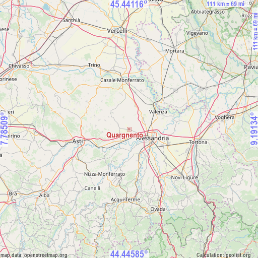
Quargnento GPS coordinates[2]
44° 56' 44.376" North, 8° 29' 17.556" East
| Map corner | latitude | longitude |
|---|---|---|
| Upper-left | 45.44116°, | 7.78509° |
| Center: | 44.94566°, | 8.48821° |
| Lower-right: | 44.44585°, | 9.19134° |
| Map W x H: | 110.7×110.7 km | = 68.8×68.8mi |
| max Lat: | 47.04031° ⇑41.3% North |
| Quargnento: | 44.94566° |
| min Lat: | ⇓58.7% South 35.50142° |
| min Long | Quargnento | max Long |
| 6.69888° | 8.48821° | 18.48682° |
| W 11.9%⇐ | ⇒88.1% E |
Elevation
Elevation of Quargnento is 119 m = 390 ft, and this is 187.7 m = 616 ft below average elevation for this country.
| Max E: |
2085 m = 6841 ft | 66.3% |
| Avg. | 306.7 m = 1006 ft | |
| Quargnento | 119 m = 390 ft | |
Min E: |
-4 m = -13 ft | 33.7% |
See also: Italy elevation on elevation.city.
Geographical zone
Quargnento is located in North temperate zone (between Tropic of Cancer and the Arctic Circle). Distance of this Northern Tropic circle is 2391.6 km =1486.1 mi to South.| Distance of | km | miles | from Quargnento |
|---|---|---|---|
| North Pole | 5009.6 | 3112.8 | to North |
| Arctic Circle | 2403.7 | 1493.6 | to North |
| Tropic Cancer | 2391.6 | 1486.1 | to South |
| Equator | 4997.5 | 3105.3 | to South |


Nearby cities:
15 places around Quargnento: (largest is in red/bold)
• Cabanette
10 km =6.2 mi,  134°
134°
• Camagna Monferrato
9.2 km =5.7 mi,  330°
330°
• Cantalupo
10.1 km =6.3 mi,  149°
149°
• Casalbagliano
8.2 km =5.1 mi, 130°
• Castelletto Monferrato
7.2 km =4.5 mi,  56°
56°
• Conzano
8.7 km =5.4 mi,  342°
342°
• Cuccaro Monferrato
5.9 km =3.7 mi, 335°
• Felizzano
6.6 km =4.1 mi,  218°
218°
• Fubine
5.1 km =3.2 mi,  292°
292°
• Lu
6.2 km =3.9 mi,  358°
358°
• Oviglio
9.4 km =5.8 mi,  180°
180°
• Quattordio
8.4 km =5.2 mi,  231°
231°
• San Michele
7.5 km =4.7 mi,  104°
104°
• San Salvatore Monferrato
8.2 km =5.1 mi,  48°
48°
• Solero
3.4 km =2.1 mi, 153°
Sources, notices
• [Note1] Compared only with cities in Italy existing in our database
• [Src1] Map data: © OpenStreetMap contributors (CC-BY-SA)
• [Src2] Other city data from geonames.org with taken over terms of usage.
• [Src3] Geographical zone / Annual Mean Temperature by Robert A. Rohde @ Wikipedia
