Casalbagliano geodata
Casalbagliano (Piedmont) is a populated place; located in Italy in Europe/Rome (GMT+2) time zone. With population of 945 people, there are 6891 cities with bigger population in this country. Compared to other cities in Italy, 57.8% of cities are located further ↓South; 87.1% of cities are located further →East and 70.4% of cities have higher elevation than Casalbagliano. Note1
Administrative division(s):
- Level 1: Piedmont
- Level 2: Provincia di Alessandria
- Level 3: Alessandria


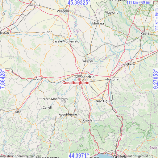
Casalbagliano GPS coordinates[2]
44° 53' 50.388" North, 8° 34' 2.64" East
| Map corner | latitude | longitude |
|---|---|---|
| Upper-left | 45.39325°, | 7.86428° |
| Center: | 44.89733°, | 8.5674° |
| Lower-right: | 44.3971°, | 9.27053° |
| Map W x H: | 110.8×110.8 km | = 68.8×68.8mi |
| max Lat: | 47.04031° ⇑42.2% North |
| Casalbagliano: | 44.89733° |
| min Lat: | ⇓57.8% South 35.50142° |
| min Long | Casalbagliano | max Long |
| 6.69888° | 8.5674° | 18.48682° |
| W 12.9%⇐ | ⇒87.1% E |
Elevation
Elevation of Casalbagliano is 95 m = 312 ft, and this is 211.7 m = 695 ft below average elevation for this country.
| Max E: |
2085 m = 6841 ft | 70.4% |
| Avg. | 306.7 m = 1006 ft | |
| Casalbagliano | 95 m = 312 ft | |
Min E: |
-4 m = -13 ft | 29.6% |
See also: Italy elevation on elevation.city.
Geographical zone
Casalbagliano is located in North temperate zone (between Tropic of Cancer and the Arctic Circle). Distance of this Northern Tropic circle is 2386.2 km =1482.7 mi to South.| Distance of | km | miles | from Casalbagliano |
|---|---|---|---|
| North Pole | 5014.9 | 3116.1 | to North |
| Arctic Circle | 2409.1 | 1496.9 | to North |
| Tropic Cancer | 2386.2 | 1482.7 | to South |
| Equator | 4992.1 | 3101.9 | to South |


Nearby cities:
15 places around Casalbagliano: (largest is in red/bold)
• Alessandria
3.6 km =2.2 mi,  68°
68°
• Borgoratto Alessandrino
7.2 km =4.5 mi,  198°
198°
• Cabanette
1.8 km =1.1 mi,  151°
151°
• Cantalupo
3.6 km =2.2 mi, 198°
• Casal Cermelli
8.3 km =5.2 mi, 146°
• Castellazzo Bormida
6.1 km =3.8 mi,  171°
171°
• Castelletto Monferrato
9.3 km =5.8 mi,  358°
358°
• Frascaro
8.5 km =5.3 mi, 199°
• Oviglio
7.4 km =4.6 mi,  237°
237°
• Quargnento
8.2 km =5.1 mi,  310°
310°
• San Michele
3.6 km =2.2 mi,  15°
15°
• Solero
5.3 km =3.3 mi,  296°
296°
• Spinetta Marengo
8.8 km =5.5 mi,  98°
98°
• Valle San Bartolomeo
8.2 km =5.1 mi,  44°
44°
• Valmadonna
9.2 km =5.7 mi, 22°
Sources, notices
• [Note1] Compared only with cities in Italy existing in our database
• [Src1] Map data: © OpenStreetMap contributors (CC-BY-SA)
• [Src2] Other city data from geonames.org with taken over terms of usage.
• [Src3] Geographical zone / Annual Mean Temperature by Robert A. Rohde @ Wikipedia
