Solero geodata
Solero (Piedmont) is a seat of a third-order administrative division; located in Italy in Europe/Rome (GMT+2) time zone. With population of 1,426 people, there are 5304 cities with bigger population in this country. Compared to other cities in Italy, 58.3% of cities are located further ↓South; 87.9% of cities are located further →East and 69.2% of cities have higher elevation than Solero. Note1


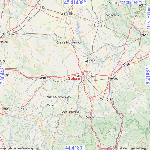
Solero GPS coordinates[2]
44° 55' 6.06" North, 8° 30' 27.144" East
| Map corner | latitude | longitude |
|---|---|---|
| Upper-left | 45.41409°, | 7.80442° |
| Center: | 44.91835°, | 8.50754° |
| Lower-right: | 44.4183°, | 9.21067° |
| Map W x H: | 110.7×110.7 km | = 68.8×68.8mi |
| max Lat: | 47.04031° ⇑41.7% North |
| Solero: | 44.91835° |
| min Lat: | ⇓58.3% South 35.50142° |
| min Long | Solero | max Long |
| 6.69888° | 8.50754° | 18.48682° |
| W 12.1%⇐ | ⇒87.9% E |
Elevation
Elevation of Solero is 102 m = 335 ft, and this is 204.7 m = 672 ft below average elevation for this country.
| Max E: |
2085 m = 6841 ft | 69.2% |
| Avg. | 306.7 m = 1006 ft | |
| Solero | 102 m = 335 ft | |
Min E: |
-4 m = -13 ft | 30.8% |
See also: Italy elevation on elevation.city.
Geographical zone
Solero is located in North temperate zone (between Tropic of Cancer and the Arctic Circle). Distance of this Northern Tropic circle is 2388.5 km =1484.1 mi to South.| Distance of | km | miles | from Solero |
|---|---|---|---|
| North Pole | 5012.6 | 3114.7 | to North |
| Arctic Circle | 2406.7 | 1495.5 | to North |
| Tropic Cancer | 2388.5 | 1484.1 | to South |
| Equator | 4994.5 | 3103.4 | to South |


Nearby cities:
15 places around Solero: (largest is in red/bold)
• Alessandria
8.1 km =5 mi,  97°
97°
• Borgoratto Alessandrino
9.4 km =5.8 mi,  165°
165°
• Cabanette
6.9 km =4.3 mi,  125°
125°
• Cantalupo
6.7 km =4.2 mi,  148°
148°
• Casalbagliano
5.3 km =3.3 mi,  116°
116°
• Castelletto Monferrato
8.3 km =5.2 mi,  32°
32°
• Cuccaro Monferrato
9.3 km =5.8 mi,  334°
334°
• Felizzano
6 km =3.7 mi,  249°
249°
• Fubine
8 km =5 mi,  308°
308°
• Lu
9.4 km =5.8 mi,  349°
349°
• Masio
9.5 km =5.9 mi,  235°
235°
• Oviglio
6.5 km =4 mi,  193°
193°
• Quargnento
3.4 km =2.1 mi, 333°
• Quattordio
8.4 km =5.2 mi, 254°
• San Michele
5.8 km =3.6 mi,  78°
78°
Sources, notices
• [Note1] Compared only with cities in Italy existing in our database
• [Src1] Map data: © OpenStreetMap contributors (CC-BY-SA)
• [Src2] Other city data from geonames.org with taken over terms of usage.
• [Src3] Geographical zone / Annual Mean Temperature by Robert A. Rohde @ Wikipedia
