Prata geodata
Prata (Tuscany) is a populated place; located in Italy in Europe/Rome (GMT+2) time zone. With population of 584 people, there are 9143 cities with bigger population in this country. Compared to other cities in Italy, 62.7% of cities are located further ↑North; 57.5% of cities are located further →East and 84.8% of cities have lower elevation than Prata. Note1
Administrative division(s):
- Level 1: Tuscany
- Level 2: Provincia di Grosseto
- Level 3: Massa Marittima


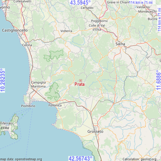
Prata GPS coordinates[2]
43° 4' 59.232" North, 10° 59' 7.692" East
| Map corner | latitude | longitude |
|---|---|---|
| Upper-left | 43.5945°, | 10.28235° |
| Center: | 43.08312°, | 10.98547° |
| Lower-right: | 42.56743°, | 11.6886° |
| Map W x H: | 114.2×114.2 km | = 71×71mi |
| max Lat: | 47.04031° ⇑62.7% North |
| Prata: | 43.08312° |
| min Lat: | ⇓37.3% South 35.50142° |
| min Long | Prata | max Long |
| 6.69888° | 10.98547° | 18.48682° |
| W 42.5%⇐ | ⇒57.5% E |
Elevation
Elevation of Prata is 607 m = 1991 ft, and this is 300.3 m = 985 ft above average elevation for this country.
| Max E: |
2085 m = 6841 ft | 15.2% |
| Prata | 607 m 1991 ft | |
| Avg. | 306.7 m = 1006 ft | |
Min E: |
-4 m = -13 ft | 84.8% |
See also: Italy elevation on elevation.city.
Geographical zone
Prata is located in North temperate zone (between Tropic of Cancer and the Arctic Circle). Distance of this Northern Tropic circle is 2184.5 km =1357.4 mi to South.| Distance of | km | miles | from Prata |
|---|---|---|---|
| North Pole | 5216.7 | 3241.5 | to North |
| Arctic Circle | 2610.8 | 1622.3 | to North |
| Tropic Cancer | 2184.5 | 1357.4 | to South |
| Equator | 4790.4 | 2976.6 | to South |


Nearby cities:
15 places around Prata: (largest is in red/bold)
• Castelnuovo di Val di Cecina
15.7 km =9.8 mi,  335°
335°
• Chiusdino
11.2 km =7 mi,  44°
44°
• Filare-Boschetto-Miniera
18.8 km =11.7 mi,  201°
201°
• Gavorrano
18.7 km =11.6 mi, 200°
• Massa Marittima
8.5 km =5.3 mi,  242°
242°
• Montecerboli
20.3 km =12.6 mi,  334°
334°
• Monterotondo Marittimo
12.6 km =7.8 mi,  303°
303°
• Monticiano
16.8 km =10.4 mi,  67°
67°
• Montieri
5.9 km =3.7 mi,  25°
25°
• Radicondoli
20.3 km =12.6 mi,  13°
13°
• Ribolla
13.1 km =8.1 mi,  161°
161°
• Roccastrada
16.9 km =10.5 mi,  119°
119°
• Roccatederighi
9.9 km =6.2 mi,  128°
128°
• Sassofortino
12.1 km =7.5 mi, 121°
• Scarlino Scalo
19.9 km =12.4 mi,  217°
217°
Sources, notices
• [Note1] Compared only with cities in Italy existing in our database
• [Src1] Map data: © OpenStreetMap contributors (CC-BY-SA)
• [Src2] Other city data from geonames.org with taken over terms of usage.
• [Src3] Geographical zone / Annual Mean Temperature by Robert A. Rohde @ Wikipedia
