Portobuffolè geodata
Portobuffolè (Veneto) is a seat of a third-order administrative division; located in Italy in Europe/Rome (GMT+2) time zone. With population of 629 people, there are 8780 cities with bigger population in this country. Compared to other cities in Italy, 87.8% of cities are located further ↓South; 62.8% of cities are located further ←West and 94.1% of cities have higher elevation than Portobuffolè. Note1


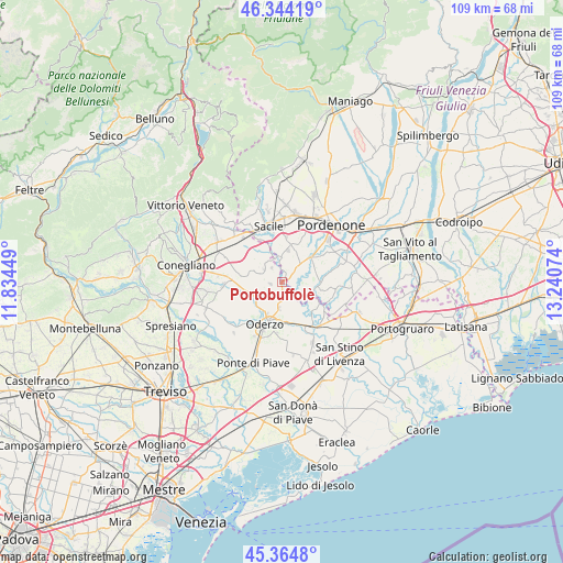
Portobuffolè GPS coordinates[2]
45° 51' 23.94" North, 12° 32' 15.396" East
| Map corner | latitude | longitude |
|---|---|---|
| Upper-left | 46.34419°, | 11.83449° |
| Center: | 45.85665°, | 12.53761° |
| Lower-right: | 45.3648°, | 13.24074° |
| Map W x H: | 108.9×108.9 km | = 67.7×67.7mi |
| max Lat: | 47.04031° ⇑12.2% North |
| Portobuffolè: | 45.85665° |
| min Lat: | ⇓87.8% South 35.50142° |
| min Long | Portobuffolè | max Long |
| 6.69888° | 12.53761° | 18.48682° |
| W 62.8%⇐ | ⇒37.2% E |
Elevation
Elevation of Portobuffolè is 10 m = 33 ft, and this is 296.7 m = 973 ft below average elevation for this country.
| Max E: |
2085 m = 6841 ft | 94.1% |
| Avg. | 306.7 m = 1006 ft | |
| Portobuffolè | 10 m = 33 ft | |
Min E: |
-4 m = -13 ft | 5.9% |
See also: Italy elevation on elevation.city.
Geographical zone
Portobuffolè is located in North temperate zone (between Tropic of Cancer and the Arctic Circle). Distance of this North polar circle is 2302.4 km =1430.6 mi to North.| Distance of | km | miles | from Portobuffolè |
|---|---|---|---|
| North Pole | 4908.3 | 3049.9 | to North |
| Arctic Circle | 2302.4 | 1430.6 | to North |
| Tropic Cancer | 2492.9 | 1549 | to South |
| Equator | 5098.8 | 3168.2 | to South |


Nearby cities:
15 places around Portobuffolè: (largest is in red/bold)
• Albina
3.4 km =2.1 mi,  327°
327°
• Brugnera
4.8 km =3 mi,  3°
3°
• Cecchini
6.6 km =4.1 mi,  81°
81°
• Fontanelle
6.1 km =3.8 mi,  244°
244°
• Francenigo
6.3 km =3.9 mi,  335°
335°
• Gaiarine
5.1 km =3.2 mi,  301°
301°
• Ghirano
2.5 km =1.6 mi,  121°
121°
• Lutrano
6.9 km =4.3 mi,  226°
226°
• Mansuè
3.9 km =2.4 mi,  182°
182°
• Pasiano
7 km =4.3 mi,  96°
96°
• Pozzo
5.8 km =3.6 mi, 96°
• Prata di Pordenone
5.8 km =3.6 mi,  43°
43°
• Prata di Sotto
5.9 km =3.7 mi,  49°
49°
• Puia-Villanova
2.7 km =1.7 mi, 76°
• Roverbasso
6.7 km =4.2 mi,  286°
286°
Sources, notices
• [Note1] Compared only with cities in Italy existing in our database
• [Src1] Map data: © OpenStreetMap contributors (CC-BY-SA)
• [Src2] Other city data from geonames.org with taken over terms of usage.
• [Src3] Geographical zone / Annual Mean Temperature by Robert A. Rohde @ Wikipedia
