Albina geodata
Albina (Veneto) is a populated place; located in Italy in Europe/Rome (GMT+2) time zone. With population of 655 people, there are 8600 cities with bigger population in this country. Compared to other cities in Italy, 88.7% of cities are located further ↓South; 62.5% of cities are located further ←West and 91.1% of cities have higher elevation than Albina. Note1


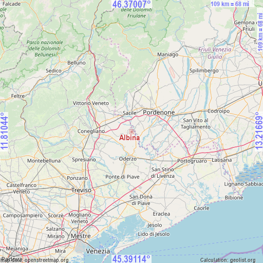
Albina GPS coordinates[2]
45° 52' 57.936" North, 12° 30' 48.816" East
| Map corner | latitude | longitude |
|---|---|---|
| Upper-left | 46.37007°, | 11.81044° |
| Center: | 45.88276°, | 12.51356° |
| Lower-right: | 45.39114°, | 13.21669° |
| Map W x H: | 108.8×108.8 km | = 67.6×67.6mi |
| max Lat: | 47.04031° ⇑11.3% North |
| Albina: | 45.88276° |
| min Lat: | ⇓88.7% South 35.50142° |
| min Long | Albina | max Long |
| 6.69888° | 12.51356° | 18.48682° |
| W 62.5%⇐ | ⇒37.5% E |
Elevation
Elevation of Albina is 16 m = 52 ft, and this is 290.7 m = 954 ft below average elevation for this country.
| Max E: |
2085 m = 6841 ft | 91.1% |
| Avg. | 306.7 m = 1006 ft | |
| Albina | 16 m = 52 ft | |
Min E: |
-4 m = -13 ft | 8.9% |
See also: Italy elevation on elevation.city.
Geographical zone
Albina is located in North temperate zone (between Tropic of Cancer and the Arctic Circle). Distance of this North polar circle is 2299.5 km =1428.8 mi to North.| Distance of | km | miles | from Albina |
|---|---|---|---|
| North Pole | 4905.4 | 3048.1 | to North |
| Arctic Circle | 2299.5 | 1428.8 | to North |
| Tropic Cancer | 2495.8 | 1550.8 | to South |
| Equator | 5101.7 | 3170 | to South |


Nearby cities:
15 places around Albina: (largest is in red/bold)
• Bibano
6.8 km =4.2 mi,  293°
293°
• Brugnera
2.9 km =1.8 mi,  49°
49°
• Cavolano-Schiavoi
5.7 km =3.5 mi,  349°
349°
• Fontanelle
6.6 km =4.1 mi,  213°
213°
• Francenigo
2.9 km =1.8 mi,  344°
344°
• Gaiarine
2.5 km =1.6 mi,  265°
265°
• Ghirano
5.8 km =3.6 mi,  136°
136°
• Mansuè
7 km =4.3 mi,  166°
166°
• Portobuffolè
3.4 km =2.1 mi,  147°
147°
• Prata di Pordenone
5.9 km =3.7 mi,  77°
77°
• Prata di Sotto
6.4 km =4 mi, 82°
• Puia-Villanova
5 km =3.1 mi,  117°
117°
• Roverbasso
4.6 km =2.9 mi,  257°
257°
• San Giovanni di Livenza
4.2 km =2.6 mi,  2°
2°
• Tamai
6.5 km =4 mi,  44°
44°
Sources, notices
• [Note1] Compared only with cities in Italy existing in our database
• [Src1] Map data: © OpenStreetMap contributors (CC-BY-SA)
• [Src2] Other city data from geonames.org with taken over terms of usage.
• [Src3] Geographical zone / Annual Mean Temperature by Robert A. Rohde @ Wikipedia
