Roverbasso geodata
Roverbasso (Veneto) is a populated place; located in Italy in Europe/Rome (GMT+2) time zone. With population of 556 people, there are 9392 cities with bigger population in this country. Compared to other cities in Italy, 88.4% of cities are located further ↓South; 61.9% of cities are located further ←West and 88.7% of cities have higher elevation than Roverbasso. Note1


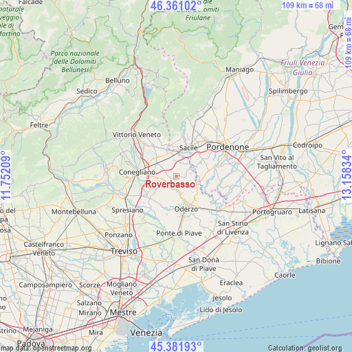
Roverbasso GPS coordinates[2]
45° 52' 25.068" North, 12° 27' 18.756" East
| Map corner | latitude | longitude |
|---|---|---|
| Upper-left | 46.36102°, | 11.75209° |
| Center: | 45.87363°, | 12.45521° |
| Lower-right: | 45.38193°, | 13.15834° |
| Map W x H: | 108.9×108.9 km | = 67.7×67.7mi |
| max Lat: | 47.04031° ⇑11.6% North |
| Roverbasso: | 45.87363° |
| min Lat: | ⇓88.4% South 35.50142° |
| min Long | Roverbasso | max Long |
| 6.69888° | 12.45521° | 18.48682° |
| W 61.9%⇐ | ⇒38.1% E |
Elevation
Elevation of Roverbasso is 21 m = 69 ft, and this is 285.7 m = 937 ft below average elevation for this country.
| Max E: |
2085 m = 6841 ft | 88.7% |
| Avg. | 306.7 m = 1006 ft | |
| Roverbasso | 21 m = 69 ft | |
Min E: |
-4 m = -13 ft | 11.3% |
See also: Italy elevation on elevation.city.
Geographical zone
Roverbasso is located in North temperate zone (between Tropic of Cancer and the Arctic Circle). Distance of this North polar circle is 2300.5 km =1429.5 mi to North.| Distance of | km | miles | from Roverbasso |
|---|---|---|---|
| North Pole | 4906.4 | 3048.7 | to North |
| Arctic Circle | 2300.5 | 1429.5 | to North |
| Tropic Cancer | 2494.8 | 1550.2 | to South |
| Equator | 5100.7 | 3169.4 | to South |


Nearby cities:
15 places around Roverbasso: (largest is in red/bold)
• Albina
4.6 km =2.9 mi,  77°
77°
• Bibano
4.2 km =2.6 mi,  335°
335°
• Brugnera
7.3 km =4.5 mi,  66°
66°
• Cavolano-Schiavoi
7.5 km =4.7 mi,  27°
27°
• Codognè
3.6 km =2.2 mi,  245°
245°
• Cosniga-Zoppè
7.5 km =4.7 mi,  281°
281°
• Fontanelle
4.5 km =2.8 mi,  169°
169°
• Francenigo
5.3 km =3.3 mi,  44°
44°
• Gaiarine
2.2 km =1.4 mi, 68°
• Lutrano
6.8 km =4.2 mi, 168°
• Orsago
6.6 km =4.1 mi, 340°
• Portobuffolè
6.7 km =4.2 mi,  106°
106°
• San Fior di Sotto
7 km =4.3 mi,  298°
298°
• San Giovanni di Livenza
7 km =4.3 mi, 41°
• Vazzola
5.6 km =3.5 mi,  220°
220°
Sources, notices
• [Note1] Compared only with cities in Italy existing in our database
• [Src1] Map data: © OpenStreetMap contributors (CC-BY-SA)
• [Src2] Other city data from geonames.org with taken over terms of usage.
• [Src3] Geographical zone / Annual Mean Temperature by Robert A. Rohde @ Wikipedia
