Porporano geodata
Porporano (Emilia-Romagna) is a populated place; located in Italy in Europe/Rome (GMT+2) time zone. With population of 1,104 people, there are 6283 cities with bigger population in this country. Compared to other cities in Italy, 55.3% of cities are located further ↓South; 64.4% of cities are located further →East and 73.3% of cities have higher elevation than Porporano. Note1


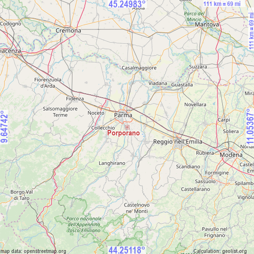
Porporano GPS coordinates[2]
44° 45' 9.576" North, 10° 21' 1.944" East
| Map corner | latitude | longitude |
|---|---|---|
| Upper-left | 45.24983°, | 9.64742° |
| Center: | 44.75266°, | 10.35054° |
| Lower-right: | 44.25118°, | 11.05367° |
| Map W x H: | 111×111 km | = 69×69mi |
| max Lat: | 47.04031° ⇑44.7% North |
| Porporano: | 44.75266° |
| min Lat: | ⇓55.3% South 35.50142° |
| min Long | Porporano | max Long |
| 6.69888° | 10.35054° | 18.48682° |
| W 35.6%⇐ | ⇒64.4% E |
Elevation
Elevation of Porporano is 82 m = 269 ft, and this is 224.7 m = 737 ft below average elevation for this country.
| Max E: |
2085 m = 6841 ft | 73.3% |
| Avg. | 306.7 m = 1006 ft | |
| Porporano | 82 m = 269 ft | |
Min E: |
-4 m = -13 ft | 26.7% |
See also: Italy elevation on elevation.city.
Geographical zone
Porporano is located in North temperate zone (between Tropic of Cancer and the Arctic Circle). Distance of this Northern Tropic circle is 2370.1 km =1472.7 mi to South.| Distance of | km | miles | from Porporano |
|---|---|---|---|
| North Pole | 5031 | 3126.1 | to North |
| Arctic Circle | 2425.1 | 1506.9 | to North |
| Tropic Cancer | 2370.1 | 1472.7 | to South |
| Equator | 4976 | 3091.9 | to South |


Nearby cities:
15 places around Porporano: (largest is in red/bold)
• Alberi
1.7 km =1.1 mi,  253°
253°
• Basilicagoiano
6.8 km =4.2 mi,  140°
140°
• Basilicanova
6.1 km =3.8 mi,  178°
178°
• Botteghino
1.4 km =0.9 mi,  130°
130°
• Carignano
6.7 km =4.2 mi,  244°
244°
• Corcagnano
5.2 km =3.2 mi,  227°
227°
• Gaione
4.8 km =3 mi,  277°
277°
• Monticelli Terme
4.4 km =2.7 mi, 127°
• Parma
5.5 km =3.4 mi,  339°
339°
• Pilastrello
3 km =1.9 mi, 141°
• San Prospero
4.8 km =3 mi,  56°
56°
• Sant'Ilario d'Enza
7.7 km =4.8 mi,  84°
84°
• Taneto
8.6 km =5.3 mi, 75°
• Vicofertile
7.9 km =4.9 mi,  297°
297°
• Vigatto
4 km =2.5 mi,  203°
203°
Sources, notices
• [Note1] Compared only with cities in Italy existing in our database
• [Src1] Map data: © OpenStreetMap contributors (CC-BY-SA)
• [Src2] Other city data from geonames.org with taken over terms of usage.
• [Src3] Geographical zone / Annual Mean Temperature by Robert A. Rohde @ Wikipedia
