Alberi geodata
Alberi (Emilia-Romagna) is a populated place; located in Italy in Europe/Rome (GMT+2) time zone. With population of 1,110 people, there are 6255 cities with bigger population in this country. Compared to other cities in Italy, 55.2% of cities are located further ↓South; 64.7% of cities are located further →East and 72.5% of cities have higher elevation than Alberi. Note1


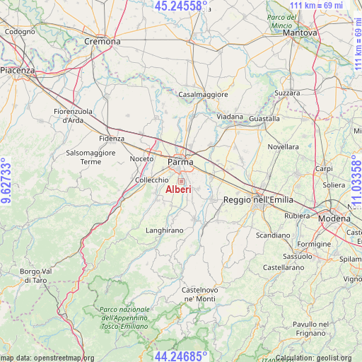
Alberi GPS coordinates[2]
44° 44' 54.132" North, 10° 19' 49.62" East
| Map corner | latitude | longitude |
|---|---|---|
| Upper-left | 45.24558°, | 9.62733° |
| Center: | 44.74837°, | 10.33045° |
| Lower-right: | 44.24685°, | 11.03358° |
| Map W x H: | 111×111 km | = 69×69mi |
| max Lat: | 47.04031° ⇑44.8% North |
| Alberi: | 44.74837° |
| min Lat: | ⇓55.2% South 35.50142° |
| min Long | Alberi | max Long |
| 6.69888° | 10.33045° | 18.48682° |
| W 35.3%⇐ | ⇒64.7% E |
Elevation
Elevation of Alberi is 85 m = 279 ft, and this is 221.7 m = 727 ft below average elevation for this country.
| Max E: |
2085 m = 6841 ft | 72.5% |
| Avg. | 306.7 m = 1006 ft | |
| Alberi | 85 m = 279 ft | |
Min E: |
-4 m = -13 ft | 27.5% |
See also: Italy elevation on elevation.city.
Geographical zone
Alberi is located in North temperate zone (between Tropic of Cancer and the Arctic Circle). Distance of this Northern Tropic circle is 2369.6 km =1472.4 mi to South.| Distance of | km | miles | from Alberi |
|---|---|---|---|
| North Pole | 5031.5 | 3126.4 | to North |
| Arctic Circle | 2425.6 | 1507.2 | to North |
| Tropic Cancer | 2369.6 | 1472.4 | to South |
| Equator | 4975.6 | 3091.7 | to South |


Nearby cities:
15 places around Alberi: (largest is in red/bold)
• Basilicagoiano
7.6 km =4.7 mi,  129°
129°
• Basilicanova
5.9 km =3.7 mi,  162°
162°
• Botteghino
2.7 km =1.7 mi,  99°
99°
• Carignano
5 km =3.1 mi,  241°
241°
• Corcagnano
3.7 km =2.3 mi,  215°
215°
• Gaione
3.4 km =2.1 mi,  289°
289°
• Monticelli Terme
5.5 km =3.4 mi,  113°
113°
• Pannocchia
8.1 km =5 mi,  191°
191°
• Parma
5.7 km =3.5 mi,  356°
356°
• Pilastrello
3.9 km =2.4 mi,  118°
118°
• Pilastro
8 km =5 mi,  204°
204°
• Porporano
1.7 km =1.1 mi,  73°
73°
• San Prospero
6.4 km =4 mi,  60°
60°
• Vicofertile
6.8 km =4.2 mi,  307°
307°
• Vigatto
3.2 km =2 mi,  180°
180°
Sources, notices
• [Note1] Compared only with cities in Italy existing in our database
• [Src1] Map data: © OpenStreetMap contributors (CC-BY-SA)
• [Src2] Other city data from geonames.org with taken over terms of usage.
• [Src3] Geographical zone / Annual Mean Temperature by Robert A. Rohde @ Wikipedia
