Botteghino geodata
Botteghino (Emilia-Romagna) is a populated place; located in Italy in Europe/Rome (GMT+2) time zone. With population of 870 people, there are 7316 cities with bigger population in this country. Compared to other cities in Italy, 55.1% of cities are located further ↓South; 64.3% of cities are located further →East and 73.3% of cities have higher elevation than Botteghino. Note1


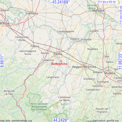
Botteghino GPS coordinates[2]
44° 44' 40.02" North, 10° 21' 51.192" East
| Map corner | latitude | longitude |
|---|---|---|
| Upper-left | 45.24169°, | 9.6611° |
| Center: | 44.74445°, | 10.36422° |
| Lower-right: | 44.2429°, | 11.06735° |
| Map W x H: | 111.1×111.1 km | = 69×69mi |
| max Lat: | 47.04031° ⇑44.9% North |
| Botteghino: | 44.74445° |
| min Lat: | ⇓55.1% South 35.50142° |
| min Long | Botteghino | max Long |
| 6.69888° | 10.36422° | 18.48682° |
| W 35.7%⇐ | ⇒64.3% E |
Elevation
Elevation of Botteghino is 82 m = 269 ft, and this is 224.7 m = 737 ft below average elevation for this country.
| Max E: |
2085 m = 6841 ft | 73.3% |
| Avg. | 306.7 m = 1006 ft | |
| Botteghino | 82 m = 269 ft | |
Min E: |
-4 m = -13 ft | 26.7% |
See also: Italy elevation on elevation.city.
Geographical zone
Botteghino is located in North temperate zone (between Tropic of Cancer and the Arctic Circle). Distance of this Northern Tropic circle is 2369.2 km =1472.2 mi to South.| Distance of | km | miles | from Botteghino |
|---|---|---|---|
| North Pole | 5031.9 | 3126.7 | to North |
| Arctic Circle | 2426.1 | 1507.5 | to North |
| Tropic Cancer | 2369.2 | 1472.2 | to South |
| Equator | 4975.1 | 3091.4 | to South |


Nearby cities:
15 places around Botteghino: (largest is in red/bold)
• Alberi
2.7 km =1.7 mi,  279°
279°
• Basilicagoiano
5.4 km =3.4 mi,  143°
143°
• Basilicanova
5.2 km =3.2 mi,  190°
190°
• Carignano
7.4 km =4.6 mi,  254°
254°
• Corcagnano
5.5 km =3.4 mi,  241°
241°
• Gaione
6 km =3.7 mi, 284°
• Montechiarugolo
7.3 km =4.5 mi, 141°
• Monticelli Terme
3 km =1.9 mi,  126°
126°
• Parma
6.8 km =4.2 mi,  333°
333°
• Pilastrello
1.6 km =1 mi,  151°
151°
• Porporano
1.4 km =0.9 mi,  310°
310°
• San Prospero
4.6 km =2.9 mi,  39°
39°
• Sant'Ilario d'Enza
6.8 km =4.2 mi,  76°
76°
• Taneto
7.8 km =4.8 mi,  66°
66°
• Vigatto
3.8 km =2.4 mi,  224°
224°
Sources, notices
• [Note1] Compared only with cities in Italy existing in our database
• [Src1] Map data: © OpenStreetMap contributors (CC-BY-SA)
• [Src2] Other city data from geonames.org with taken over terms of usage.
• [Src3] Geographical zone / Annual Mean Temperature by Robert A. Rohde @ Wikipedia
