Polla geodata
Polla (Campania) is a seat of a third-order administrative division; located in Italy in Europe/Rome (GMT+2) time zone. With population of 5,182 people, there are 1884 cities with bigger population in this country. Compared to other cities in Italy, 84.1% of cities are located further ↑North; 90.6% of cities are located further ←West and 74.5% of cities have lower elevation than Polla. Note1


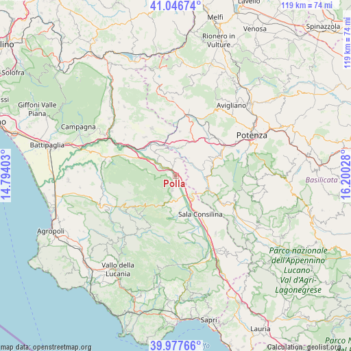
Polla GPS coordinates[2]
40° 30' 51.588" North, 15° 29' 49.74" East
| Map corner | latitude | longitude |
|---|---|---|
| Upper-left | 41.04674°, | 14.79403° |
| Center: | 40.51433°, | 15.49715° |
| Lower-right: | 39.97766°, | 16.20028° |
| Map W x H: | 118.9×118.9 km | = 73.9×73.9mi |
| max Lat: | 47.04031° ⇑84.1% North |
| Polla: | 40.51433° |
| min Lat: | ⇓15.9% South 35.50142° |
| min Long | Polla | max Long |
| 6.69888° | 15.49715° | 18.48682° |
| W 90.6%⇐ | ⇒9.4% E |
Elevation
Elevation of Polla is 445 m = 1460 ft, and this is 138.3 m = 454 ft above average elevation for this country.
| Max E: |
2085 m = 6841 ft | 25.5% |
| Polla | 445 m 1460 ft | |
| Avg. | 306.7 m = 1006 ft | |
Min E: |
-4 m = -13 ft | 74.5% |
See also: Italy elevation on elevation.city.
Geographical zone
Polla is located in North temperate zone (between Tropic of Cancer and the Arctic Circle). Distance of this Northern Tropic circle is 1898.9 km =1179.9 mi to South.| Distance of | km | miles | from Polla |
|---|---|---|---|
| North Pole | 5502.3 | 3419 | to North |
| Arctic Circle | 2896.4 | 1799.7 | to North |
| Tropic Cancer | 1898.9 | 1179.9 | to South |
| Equator | 4504.8 | 2799.2 | to South |


Nearby cities:
15 places around Polla: (largest is in red/bold)
• Atena Lucana
8.3 km =5.2 mi,  142°
142°
• Auletta
8.1 km =5 mi,  309°
309°
• Brienza
11.9 km =7.4 mi,  110°
110°
• Caggiano
5.3 km =3.3 mi,  359°
359°
• Fontana Vaglio
11 km =6.8 mi,  183°
183°
• Pertosa
5.1 km =3.2 mi, 309°
• Petina
10.6 km =6.6 mi,  280°
280°
• Salvitelle
9.1 km =5.7 mi,  338°
338°
• San Pietro al Tanagro
6.7 km =4.2 mi,  187°
187°
• San Rufo
9.3 km =5.8 mi,  197°
197°
• Sant'Angelo le Fratte
6.4 km =4 mi,  58°
58°
• Sant'Arsenio
4.9 km =3 mi, 193°
• Savoia di Lucania
7.7 km =4.8 mi,  36°
36°
• Scalo Romagnano al Monte
11.5 km =7.1 mi, 338°
• Vietri di Potenza
9.6 km =6 mi,  5°
5°
Sources, notices
• [Note1] Compared only with cities in Italy existing in our database
• [Src1] Map data: © OpenStreetMap contributors (CC-BY-SA)
• [Src2] Other city data from geonames.org with taken over terms of usage.
• [Src3] Geographical zone / Annual Mean Temperature by Robert A. Rohde @ Wikipedia
