Salvitelle geodata
Salvitelle (Campania) is a seat of a third-order administrative division; located in Italy in Europe/Rome (GMT+2) time zone. With population of 453 people, there are 10081 cities with bigger population in this country. Compared to other cities in Italy, 83.5% of cities are located further ↑North; 90.4% of cities are located further ←West and 83.2% of cities have lower elevation than Salvitelle. Note1


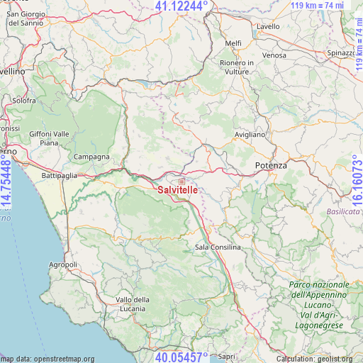
Salvitelle GPS coordinates[2]
40° 35' 26.304" North, 15° 27' 27.36" East
| Map corner | latitude | longitude |
|---|---|---|
| Upper-left | 41.12244°, | 14.75448° |
| Center: | 40.59064°, | 15.4576° |
| Lower-right: | 40.05457°, | 16.16073° |
| Map W x H: | 118.7×118.7 km | = 73.8×73.8mi |
| max Lat: | 47.04031° ⇑83.5% North |
| Salvitelle: | 40.59064° |
| min Lat: | ⇓16.5% South 35.50142° |
| min Long | Salvitelle | max Long |
| 6.69888° | 15.4576° | 18.48682° |
| W 90.4%⇐ | ⇒9.6% E |
Elevation
Elevation of Salvitelle is 575 m = 1886 ft, and this is 268.3 m = 880 ft above average elevation for this country.
| Max E: |
2085 m = 6841 ft | 16.8% |
| Salvitelle | 575 m 1886 ft | |
| Avg. | 306.7 m = 1006 ft | |
Min E: |
-4 m = -13 ft | 83.2% |
See also: Italy elevation on elevation.city.
Geographical zone
Salvitelle is located in North temperate zone (between Tropic of Cancer and the Arctic Circle). Distance of this Northern Tropic circle is 1907.3 km =1185.1 mi to South.| Distance of | km | miles | from Salvitelle |
|---|---|---|---|
| North Pole | 5493.8 | 3413.7 | to North |
| Arctic Circle | 2887.9 | 1794.5 | to North |
| Tropic Cancer | 1907.3 | 1185.1 | to South |
| Equator | 4513.3 | 2804.4 | to South |


Nearby cities:
15 places around Salvitelle: (largest is in red/bold)
• Ariola
4.6 km =2.9 mi,  334°
334°
• Auletta
4.4 km =2.7 mi,  221°
221°
• Balvano
8.1 km =5 mi,  35°
35°
• Buccino
8.2 km =5.1 mi,  308°
308°
• Caggiano
4.5 km =2.8 mi,  133°
133°
• Pertosa
5.3 km =3.3 mi,  186°
186°
• Petina
9.6 km =6 mi,  227°
227°
• Polla
9.1 km =5.7 mi,  158°
158°
• Ricigliano
8.8 km =5.5 mi,  11°
11°
• San Gregorio Magno
9.1 km =5.7 mi, 327°
• Sant'Angelo le Fratte
10.1 km =6.3 mi,  120°
120°
• Savoia di Lucania
8.3 km =5.2 mi,  106°
106°
• Scalo Romagnano al Monte
2.3 km =1.4 mi,  339°
339°
• Sicignano degli Alburni
13.3 km =8.3 mi,  254°
254°
• Vietri di Potenza
4.4 km =2.7 mi,  75°
75°
Sources, notices
• [Note1] Compared only with cities in Italy existing in our database
• [Src1] Map data: © OpenStreetMap contributors (CC-BY-SA)
• [Src2] Other city data from geonames.org with taken over terms of usage.
• [Src3] Geographical zone / Annual Mean Temperature by Robert A. Rohde @ Wikipedia
