Pinerolo geodata
Pinerolo (Piedmont) is a seat of a third-order administrative division; located in Italy in Europe/Rome (GMT+2) time zone. With population of 30,866 people, there are 265 cities with bigger population in this country. Compared to other cities in Italy, 57.7% of cities are located further ↓South; 98.8% of cities are located further →East and 68.5% of cities have lower elevation than Pinerolo. Note1


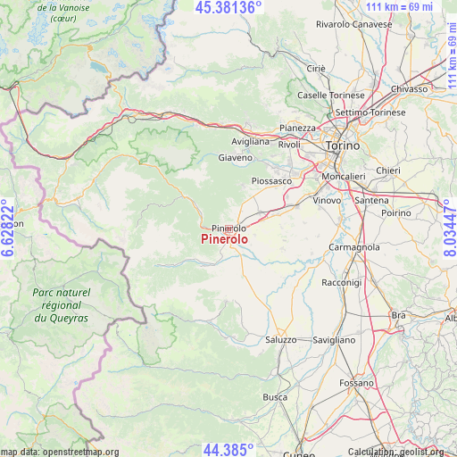
Pinerolo GPS coordinates[2]
44° 53' 7.224" North, 7° 19' 52.86" East
| Map corner | latitude | longitude |
|---|---|---|
| Upper-left | 45.38136°, | 6.62822° |
| Center: | 44.88534°, | 7.33135° |
| Lower-right: | 44.385°, | 8.03447° |
| Map W x H: | 110.8×110.8 km | = 68.8×68.8mi |
| max Lat: | 47.04031° ⇑42.3% North |
| Pinerolo: | 44.88534° |
| min Lat: | ⇓57.7% South 35.50142° |
| min Long | Pinerolo | max Long |
| 6.69888° | 7.33135° | 18.48682° |
| W 1.2%⇐ | ⇒98.8% E |
Elevation
Elevation of Pinerolo is 379 m = 1243 ft, and this is 72.3 m = 237 ft above average elevation for this country.
| Max E: |
2085 m = 6841 ft | 31.5% |
| Pinerolo | 379 m 1243 ft | |
| Avg. | 306.7 m = 1006 ft | |
Min E: |
-4 m = -13 ft | 68.5% |
See also: Italy elevation on elevation.city.
Geographical zone
Pinerolo is located in North temperate zone (between Tropic of Cancer and the Arctic Circle). Distance of this Northern Tropic circle is 2384.9 km =1481.9 mi to South.| Distance of | km | miles | from Pinerolo |
|---|---|---|---|
| North Pole | 5016.3 | 3117 | to North |
| Arctic Circle | 2410.4 | 1497.8 | to North |
| Tropic Cancer | 2384.9 | 1481.9 | to South |
| Equator | 4990.8 | 3101.1 | to South |


Nearby cities:
15 places around Pinerolo: (largest is in red/bold)
• Bricherasio
7.3 km =4.5 mi,  197°
197°
• Buriasco
6.5 km =4 mi,  102°
102°
• Cantalupa
6.7 km =4.2 mi,  359°
359°
• Frossasco
5.1 km =3.2 mi,  37°
37°
• Garzigliana
6.3 km =3.9 mi,  147°
147°
• Macello
6.5 km =4 mi,  125°
125°
• Miradolo
2.5 km =1.6 mi,  239°
239°
• Osasco
4.1 km =2.5 mi,  167°
167°
• Porte
4.9 km =3 mi,  272°
272°
• Prarostino
5.4 km =3.4 mi,  247°
247°
• Riva
4.1 km =2.5 mi,  78°
78°
• Roletto
4.3 km =2.7 mi,  1°
1°
• San Pietro Val Lemina
2.9 km =1.8 mi,  325°
325°
• San Secondo di Pinerolo
3.3 km =2.1 mi,  230°
230°
• Villar Perosa
7.5 km =4.7 mi,  299°
299°
Sources, notices
• [Note1] Compared only with cities in Italy existing in our database
• [Src1] Map data: © OpenStreetMap contributors (CC-BY-SA)
• [Src2] Other city data from geonames.org with taken over terms of usage.
• [Src3] Geographical zone / Annual Mean Temperature by Robert A. Rohde @ Wikipedia
