Frossasco geodata
Frossasco (Piedmont) is a seat of a third-order administrative division; located in Italy in Europe/Rome (GMT+2) time zone. With population of 2,464 people, there are 3568 cities with bigger population in this country. Compared to other cities in Italy, 58.3% of cities are located further ↓South; 98.6% of cities are located further →East and 62.8% of cities have lower elevation than Frossasco. Note1


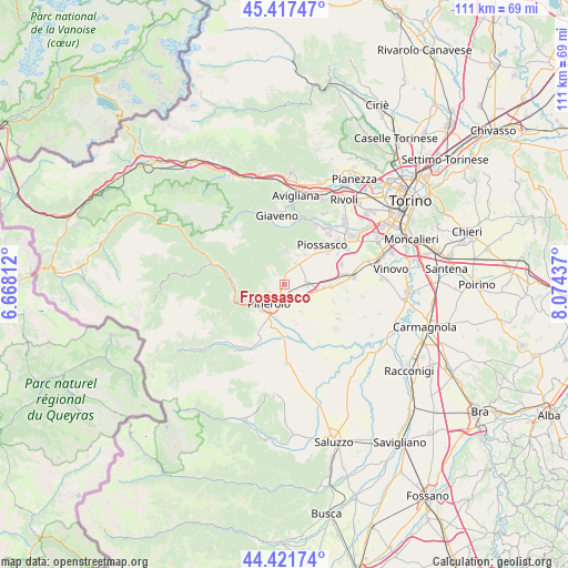
Frossasco GPS coordinates[2]
44° 55' 18.336" North, 7° 22' 16.5" East
| Map corner | latitude | longitude |
|---|---|---|
| Upper-left | 45.41747°, | 6.66812° |
| Center: | 44.92176°, | 7.37125° |
| Lower-right: | 44.42174°, | 8.07437° |
| Map W x H: | 110.7×110.7 km | = 68.8×68.8mi |
| max Lat: | 47.04031° ⇑41.7% North |
| Frossasco: | 44.92176° |
| min Lat: | ⇓58.3% South 35.50142° |
| min Long | Frossasco | max Long |
| 6.69888° | 7.37125° | 18.48682° |
| W 1.4%⇐ | ⇒98.6% E |
Elevation
Elevation of Frossasco is 321 m = 1053 ft, and this is 14.3 m = 47 ft above average elevation for this country.
| Max E: |
2085 m = 6841 ft | 37.2% |
| Frossasco | 321 m 1053 ft | |
| Avg. | 306.7 m = 1006 ft | |
Min E: |
-4 m = -13 ft | 62.8% |
See also: Italy elevation on elevation.city.
Geographical zone
Frossasco is located in North temperate zone (between Tropic of Cancer and the Arctic Circle). Distance of this Northern Tropic circle is 2388.9 km =1484.4 mi to South.| Distance of | km | miles | from Frossasco |
|---|---|---|---|
| North Pole | 5012.2 | 3114.4 | to North |
| Arctic Circle | 2406.3 | 1495.2 | to North |
| Tropic Cancer | 2388.9 | 1484.4 | to South |
| Equator | 4994.8 | 3103.6 | to South |


Nearby cities:
15 places around Frossasco: (largest is in red/bold)
• Airasca
8.8 km =5.5 mi,  93°
93°
• Buriasco
6.4 km =4 mi,  149°
149°
• Cantalupa
4.2 km =2.6 mi,  309°
309°
• Cumiana
6.1 km =3.8 mi,  4°
4°
• Macello
8.1 km =5 mi,  164°
164°
• Miradolo
7.5 km =4.7 mi,  224°
224°
• Osasco
8.3 km =5.2 mi,  195°
195°
• Pinerolo
5.1 km =3.2 mi, 217°
• Piscina
4.3 km =2.7 mi, 94°
• Porte
8.9 km =5.5 mi,  244°
244°
• Riva
3.4 km =2.1 mi,  165°
165°
• Roletto
3.1 km =1.9 mi,  275°
275°
• San Pietro Val Lemina
5 km =3.1 mi,  250°
250°
• San Secondo di Pinerolo
8.4 km =5.2 mi, 223°
• Viotto
5.8 km =3.6 mi,  111°
111°
Sources, notices
• [Note1] Compared only with cities in Italy existing in our database
• [Src1] Map data: © OpenStreetMap contributors (CC-BY-SA)
• [Src2] Other city data from geonames.org with taken over terms of usage.
• [Src3] Geographical zone / Annual Mean Temperature by Robert A. Rohde @ Wikipedia
