Prarostino geodata
Prarostino (Piedmont) is a seat of a third-order administrative division; located in Italy in Europe/Rome (GMT+2) time zone. With population of 1,302 people, there are 5630 cities with bigger population in this country. Compared to other cities in Italy, 57.3% of cities are located further ↓South; 99.1% of cities are located further →East and 91.1% of cities have lower elevation than Prarostino. Note1


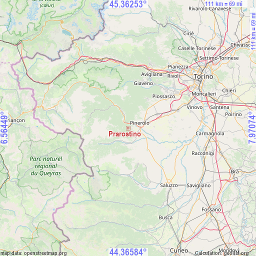
Prarostino GPS coordinates[2]
44° 51' 58.824" North, 7° 16' 3.432" East
| Map corner | latitude | longitude |
|---|---|---|
| Upper-left | 45.36253°, | 6.56449° |
| Center: | 44.86634°, | 7.26762° |
| Lower-right: | 44.36584°, | 7.97074° |
| Map W x H: | 110.8×110.8 km | = 68.8×68.8mi |
| max Lat: | 47.04031° ⇑42.7% North |
| Prarostino: | 44.86634° |
| min Lat: | ⇓57.3% South 35.50142° |
| min Long | Prarostino | max Long |
| 6.69888° | 7.26762° | 18.48682° |
| W 0.9%⇐ | ⇒99.1% E |
Elevation
Elevation of Prarostino is 747 m = 2451 ft, and this is 440.3 m = 1445 ft above average elevation for this country.
| Max E: |
2085 m = 6841 ft | 8.9% |
| Prarostino | 747 m 2451 ft | |
| Avg. | 306.7 m = 1006 ft | |
Min E: |
-4 m = -13 ft | 91.1% |
See also: Italy elevation on elevation.city.
Geographical zone
Prarostino is located in North temperate zone (between Tropic of Cancer and the Arctic Circle). Distance of this Northern Tropic circle is 2382.8 km =1480.6 mi to South.| Distance of | km | miles | from Prarostino |
|---|---|---|---|
| North Pole | 5018.4 | 3118.3 | to North |
| Arctic Circle | 2412.5 | 1499.1 | to North |
| Tropic Cancer | 2382.8 | 1480.6 | to South |
| Equator | 4988.7 | 3099.8 | to South |


Nearby cities:
15 places around Prarostino: (largest is in red/bold)
• Airali
5.7 km =3.5 mi,  192°
192°
• Angrogna
4.3 km =2.7 mi,  233°
233°
• Bricherasio
5.5 km =3.4 mi,  149°
149°
• Luserna
6.8 km =4.2 mi, 194°
• Lusernetta
7.2 km =4.5 mi, 193°
• Miradolo
3 km =1.9 mi,  73°
73°
• Osasco
6.2 km =3.9 mi,  107°
107°
• Pinerolo
5.4 km =3.4 mi, 67°
• Porte
2.3 km =1.4 mi,  4°
4°
• Pramollo
7.6 km =4.7 mi,  307°
307°
• San Germano Chisone
4.7 km =2.9 mi,  328°
328°
• San Pietro Val Lemina
5.6 km =3.5 mi,  37°
37°
• San Secondo di Pinerolo
2.4 km =1.5 mi,  89°
89°
• Torre Pellice
6.4 km =4 mi,  218°
218°
• Villar Perosa
6 km =3.7 mi,  345°
345°
Sources, notices
• [Note1] Compared only with cities in Italy existing in our database
• [Src1] Map data: © OpenStreetMap contributors (CC-BY-SA)
• [Src2] Other city data from geonames.org with taken over terms of usage.
• [Src3] Geographical zone / Annual Mean Temperature by Robert A. Rohde @ Wikipedia
