Pietracuta geodata
Pietracuta (Emilia-Romagna) is a populated place; located in Italy in Europe/Rome (GMT+2) time zone. With population of 1,016 people, there are 6598 cities with bigger population in this country. Compared to other cities in Italy, 55.2% of cities are located further ↑North; 60.9% of cities are located further ←West and 60.5% of cities have higher elevation than Pietracuta. Note1


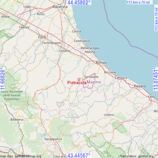
Pietracuta GPS coordinates[2]
43° 57' 14.4" North, 12° 22' 16.968" East
| Map corner | latitude | longitude |
|---|---|---|
| Upper-left | 44.45802°, | 11.66826° |
| Center: | 43.954°, | 12.37138° |
| Lower-right: | 43.44567°, | 13.07451° |
| Map W x H: | 112.6×112.6 km | = 70×70mi |
| max Lat: | 47.04031° ⇑55.2% North |
| Pietracuta: | 43.954° |
| min Lat: | ⇓44.8% South 35.50142° |
| min Long | Pietracuta | max Long |
| 6.69888° | 12.37138° | 18.48682° |
| W 60.9%⇐ | ⇒39.1% E |
Elevation
Elevation of Pietracuta is 159 m = 522 ft, and this is 147.7 m = 485 ft below average elevation for this country.
| Max E: |
2085 m = 6841 ft | 60.5% |
| Avg. | 306.7 m = 1006 ft | |
| Pietracuta | 159 m = 522 ft | |
Min E: |
-4 m = -13 ft | 39.5% |
See also: Italy elevation on elevation.city.
Geographical zone
Pietracuta is located in North temperate zone (between Tropic of Cancer and the Arctic Circle). Distance of this Northern Tropic circle is 2281.3 km =1417.5 mi to South.| Distance of | km | miles | from Pietracuta |
|---|---|---|---|
| North Pole | 5119.8 | 3181.3 | to North |
| Arctic Circle | 2513.9 | 1562.1 | to North |
| Tropic Cancer | 2281.3 | 1417.5 | to South |
| Equator | 4887.2 | 3036.8 | to South |


Nearby cities:
15 places around Pietracuta: (largest is in red/bold)
• Borghi
8.8 km =5.5 mi,  352°
352°
• Ca' Fusino
8.6 km =5.3 mi,  228°
228°
• Corpolò
9.7 km =6 mi,  41°
41°
• Novafeltria
9.3 km =5.8 mi, 225°
• Poggio Berni
8.6 km =5.3 mi,  20°
20°
• San Leo
6.8 km =4.2 mi,  198°
198°
• Sant'Andrea
9.6 km =6 mi, 23°
• Santo Marino
7.3 km =4.5 mi, 23°
• Secchiano
5.5 km =3.4 mi, 232°
• Serra di Maiolo
10.2 km =6.3 mi,  208°
208°
• Sogliano al Rubicone
8 km =5 mi,  315°
315°
• Talamello
8.8 km =5.5 mi, 232°
• Torriana
3.6 km =2.2 mi, 18°
• Verucchio
5.2 km =3.2 mi,  53°
53°
• Villa Verucchio
7.7 km =4.8 mi, 42°
Sources, notices
• [Note1] Compared only with cities in Italy existing in our database
• [Src1] Map data: © OpenStreetMap contributors (CC-BY-SA)
• [Src2] Other city data from geonames.org with taken over terms of usage.
• [Src3] Geographical zone / Annual Mean Temperature by Robert A. Rohde @ Wikipedia
