Sogliano al Rubicone geodata
Sogliano al Rubicone (Emilia-Romagna) is a seat of a third-order administrative division; located in Italy in Europe/Rome (GMT+2) time zone. With population of 682 people, there are 8413 cities with bigger population in this country. Compared to other cities in Italy, 54.6% of cities are located further ↑North; 59.9% of cities are located further ←West and 68.5% of cities have lower elevation than Sogliano al Rubicone. Note1
Administrative division(s):
- Level 1: Emilia-Romagna
- Level 2: Provincia di Forlì-Cesena
- Level 3: Sogliano al Rubicone
Current local time in Sogliano al Rubicone:
08:29 PM, WednesdayDifference from your time zone: hours


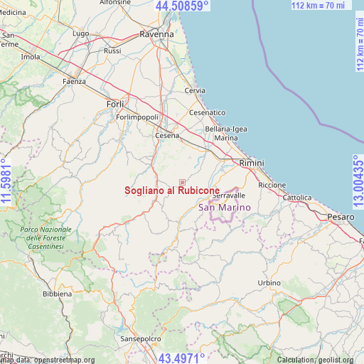
Sogliano al Rubicone GPS coordinates[2]
44° 0' 18" North, 12° 18' 4.392" East
| Map corner | latitude | longitude |
|---|---|---|
| Upper-left | 44.50859°, | 11.5981° |
| Center: | 44.005°, | 12.30122° |
| Lower-right: | 43.4971°, | 13.00435° |
| Map W x H: | 112.5×112.5 km | = 69.9×69.9mi |
| max Lat: | 47.04031° ⇑54.6% North |
| Sogliano al Rubicone: | 44.005° |
| min Lat: | ⇓45.4% South 35.50142° |
| min Long | Sogliano al Rub | max Long |
| 6.69888° | 12.30122° | 18.48682° |
| W 59.9%⇐ | ⇒40.1% E |
Elevation
Elevation of Sogliano al Rubicone is 379 m = 1243 ft, and this is 72.3 m = 237 ft above average elevation for this country.
| Max E: |
2085 m = 6841 ft | 31.5% |
| Sogliano al Rubicone | 379 m 1243 ft | |
| Avg. | 306.7 m = 1006 ft | |
Min E: |
-4 m = -13 ft | 68.5% |
See also: Italy elevation on elevation.city.
Geographical zone
Sogliano al Rubicone is located in North temperate zone (between Tropic of Cancer and the Arctic Circle). Distance of this Northern Tropic circle is 2287 km =1421.1 mi to South.| Distance of | km | miles | from Sogliano al Rubicone |
|---|---|---|---|
| North Pole | 5114.2 | 3177.8 | to North |
| Arctic Circle | 2508.3 | 1558.6 | to North |
| Tropic Cancer | 2287 | 1421.1 | to South |
| Equator | 4892.9 | 3040.3 | to South |


Nearby cities:
15 places around Sogliano al Rubicone: (largest is in red/bold)
• Bora Bassa
10.7 km =6.6 mi,  295°
295°
• Borghi
5.3 km =3.3 mi,  55°
55°
• Gualdo
8 km =5 mi,  284°
284°
• Longiano
8.1 km =5 mi,  16°
16°
• Mercato Saraceno
9.6 km =6 mi,  240°
240°
• Montiano
8.6 km =5.3 mi,  1°
1°
• Pietracuta
8 km =5 mi,  135°
135°
• Poggio Berni
9 km =5.6 mi,  74°
74°
• Roncofreddo
4.1 km =2.5 mi,  359°
359°
• Roncofreddo-Santa Paola
4.3 km =2.7 mi, 15°
• Sant'Andrea
9.9 km =6.2 mi, 71°
• Santo Marino
8.5 km =5.3 mi,  83°
83°
• Secchiano
9.1 km =5.7 mi,  172°
172°
• Torriana
7.1 km =4.4 mi,  108°
108°
• Verucchio
10.1 km =6.3 mi,  104°
104°
Sources, notices
• [Note1] Compared only with cities in Italy existing in our database
• [Src1] Map data: © OpenStreetMap contributors (CC-BY-SA)
• [Src2] Other city data from geonames.org with taken over terms of usage.
• [Src3] Geographical zone / Annual Mean Temperature by Robert A. Rohde @ Wikipedia
