Pietracamela geodata
Pietracamela (Abruzzo) is a seat of a third-order administrative division; located in Italy in Europe/Rome (GMT+2) time zone. With population of 162 people, there are 11243 cities with bigger population in this country. Compared to other cities in Italy, 66.1% of cities are located further ↑North; 74.2% of cities are located further ←West and 97.5% of cities have lower elevation than Pietracamela. Note1


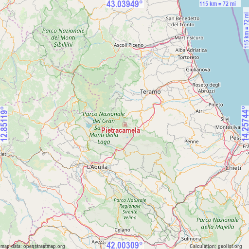
Pietracamela GPS coordinates[2]
42° 31' 24.384" North, 13° 33' 15.516" East
| Map corner | latitude | longitude |
|---|---|---|
| Upper-left | 43.03949°, | 12.85119° |
| Center: | 42.52344°, | 13.55431° |
| Lower-right: | 42.00309°, | 14.25744° |
| Map W x H: | 115.2×115.2 km | = 71.6×71.6mi |
| max Lat: | 47.04031° ⇑66.1% North |
| Pietracamela: | 42.52344° |
| min Lat: | ⇓33.9% South 35.50142° |
| min Long | Pietracamela | max Long |
| 6.69888° | 13.55431° | 18.48682° |
| W 74.2%⇐ | ⇒25.8% E |
Elevation
Elevation of Pietracamela is 1039 m = 3409 ft, and this is 732.3 m = 2403 ft above average elevation for this country.
| Max E: |
2085 m = 6841 ft | 2.5% |
| Pietracamela | 1039 m 3409 ft | |
| Avg. | 306.7 m = 1006 ft | |
Min E: |
-4 m = -13 ft | 97.5% |
See also: Italy elevation on elevation.city.
Geographical zone
Pietracamela is located in North temperate zone (between Tropic of Cancer and the Arctic Circle). Distance of this Northern Tropic circle is 2122.2 km =1318.7 mi to South.| Distance of | km | miles | from Pietracamela |
|---|---|---|---|
| North Pole | 5278.9 | 3280.2 | to North |
| Arctic Circle | 2673 | 1660.9 | to North |
| Tropic Cancer | 2122.2 | 1318.7 | to South |
| Equator | 4728.2 | 2938 | to South |


Nearby cities:
15 places around Pietracamela: (largest is in red/bold)
• Camarda
14.9 km =9.3 mi,  197°
197°
• Campotosto
15.8 km =9.8 mi,  284°
284°
• Castel Castagna
13.5 km =8.4 mi,  80°
80°
• Castelli
13.6 km =8.5 mi,  108°
108°
• Cerchiara
6.4 km =4 mi, 110°
• Colledara
10.1 km =6.3 mi, 80°
• Cortino
11.6 km =7.2 mi,  340°
340°
• Crognaleto
8.9 km =5.5 mi,  323°
323°
• Fano Adriano
3.5 km =2.2 mi, 336°
• Isola del Gran Sasso d'Italia
8.7 km =5.4 mi,  104°
104°
• Montorio al Vomano
9.3 km =5.8 mi,  46°
46°
• Nerito
6.8 km =4.2 mi,  293°
293°
• Tordinia-Villa Ripa
14.8 km =9.2 mi,  34°
34°
• Tossicia
7.9 km =4.9 mi,  72°
72°
• Valle San Giovanni
12.1 km =7.5 mi, 25°
Sources, notices
• [Note1] Compared only with cities in Italy existing in our database
• [Src1] Map data: © OpenStreetMap contributors (CC-BY-SA)
• [Src2] Other city data from geonames.org with taken over terms of usage.
• [Src3] Geographical zone / Annual Mean Temperature by Robert A. Rohde @ Wikipedia
