Colledara geodata
Colledara (Abruzzo) is a seat of a third-order administrative division; located in Italy in Europe/Rome (GMT+2) time zone. With population of 564 people, there are 9308 cities with bigger population in this country. Compared to other cities in Italy, 66.1% of cities are located further ↑North; 75.4% of cities are located further ←West and 72.2% of cities have lower elevation than Colledara. Note1


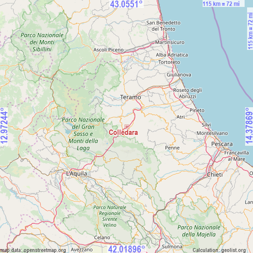
Colledara GPS coordinates[2]
42° 32' 21.048" North, 13° 40' 32.016" East
| Map corner | latitude | longitude |
|---|---|---|
| Upper-left | 43.0551°, | 12.97244° |
| Center: | 42.53918°, | 13.67556° |
| Lower-right: | 42.01896°, | 14.37869° |
| Map W x H: | 115.2×115.2 km | = 71.6×71.6mi |
| max Lat: | 47.04031° ⇑66.1% North |
| Colledara: | 42.53918° |
| min Lat: | ⇓33.9% South 35.50142° |
| min Long | Colledara | max Long |
| 6.69888° | 13.67556° | 18.48682° |
| W 75.4%⇐ | ⇒24.6% E |
Elevation
Elevation of Colledara is 417 m = 1368 ft, and this is 110.3 m = 362 ft above average elevation for this country.
| Max E: |
2085 m = 6841 ft | 27.8% |
| Colledara | 417 m 1368 ft | |
| Avg. | 306.7 m = 1006 ft | |
Min E: |
-4 m = -13 ft | 72.2% |
See also: Italy elevation on elevation.city.
Geographical zone
Colledara is located in North temperate zone (between Tropic of Cancer and the Arctic Circle). Distance of this Northern Tropic circle is 2124 km =1319.8 mi to South.| Distance of | km | miles | from Colledara |
|---|---|---|---|
| North Pole | 5277.1 | 3279 | to North |
| Arctic Circle | 2671.3 | 1659.9 | to North |
| Tropic Cancer | 2124 | 1319.8 | to South |
| Equator | 4729.9 | 2939 | to South |


Nearby cities:
15 places around Colledara: (largest is in red/bold)
• Arsita
9.9 km =6.2 mi,  114°
114°
• Basciano
8 km =5 mi,  37°
37°
• Bisenti
10.2 km =6.3 mi,  96°
96°
• Castel Castagna
3.4 km =2.1 mi,  82°
82°
• Castelli
6.7 km =4.2 mi,  153°
153°
• Cerchiara
5.6 km =3.5 mi,  225°
225°
• Isola del Gran Sasso d'Italia
4.3 km =2.7 mi,  200°
200°
• Montorio al Vomano
5.6 km =3.5 mi,  326°
326°
• Penna Sant'Andrea
10 km =6.2 mi,  52°
52°
• Pietracamela
10.1 km =6.3 mi,  260°
260°
• Tordinia-Villa Ripa
10.5 km =6.5 mi,  351°
351°
• Tossicia
2.5 km =1.6 mi,  284°
284°
• Val Vomano
10.2 km =6.3 mi, 40°
• Valle San Giovanni
10.3 km =6.4 mi, 332°
• Villa Vomano
11 km =6.8 mi, 41°
Sources, notices
• [Note1] Compared only with cities in Italy existing in our database
• [Src1] Map data: © OpenStreetMap contributors (CC-BY-SA)
• [Src2] Other city data from geonames.org with taken over terms of usage.
• [Src3] Geographical zone / Annual Mean Temperature by Robert A. Rohde @ Wikipedia
