Pico geodata
Pico (Latium) is a seat of a third-order administrative division; located in Italy in Europe/Rome (GMT+2) time zone. With population of 704 people, there are 8273 cities with bigger population in this country. Compared to other cities in Italy, 75.2% of cities are located further ↑North; 74.3% of cities are located further ←West and 59.4% of cities have higher elevation than Pico. Note1


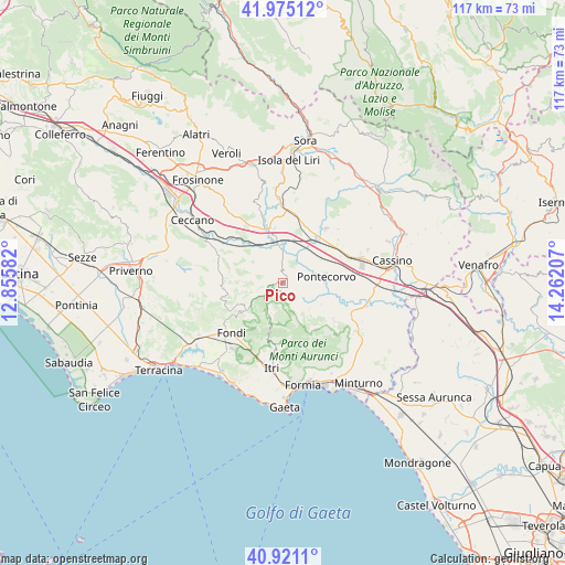
Pico GPS coordinates[2]
41° 27' 0.9" North, 13° 33' 32.184" East
| Map corner | latitude | longitude |
|---|---|---|
| Upper-left | 41.97512°, | 12.85582° |
| Center: | 41.45025°, | 13.55894° |
| Lower-right: | 40.9211°, | 14.26207° |
| Map W x H: | 117.2×117.2 km | = 72.8×72.8mi |
| max Lat: | 47.04031° ⇑75.2% North |
| Pico: | 41.45025° |
| min Lat: | ⇓24.8% South 35.50142° |
| min Long | Pico | max Long |
| 6.69888° | 13.55894° | 18.48682° |
| W 74.3%⇐ | ⇒25.7% E |
Elevation
Elevation of Pico is 168 m = 551 ft, and this is 138.7 m = 455 ft below average elevation for this country.
| Max E: |
2085 m = 6841 ft | 59.4% |
| Avg. | 306.7 m = 1006 ft | |
| Pico | 168 m = 551 ft | |
Min E: |
-4 m = -13 ft | 40.6% |
See also: Italy elevation on elevation.city.
Geographical zone
Pico is located in North temperate zone (between Tropic of Cancer and the Arctic Circle). Distance of this Northern Tropic circle is 2002.9 km =1244.5 mi to South.| Distance of | km | miles | from Pico |
|---|---|---|---|
| North Pole | 5398.2 | 3354.3 | to North |
| Arctic Circle | 2792.3 | 1735.1 | to North |
| Tropic Cancer | 2002.9 | 1244.5 | to South |
| Equator | 4608.8 | 2863.8 | to South |


Nearby cities:
15 places around Pico: (largest is in red/bold)
• Aquino
13.1 km =8.1 mi,  68°
68°
• Campodimele
7.3 km =4.5 mi,  198°
198°
• Ceprano
11.2 km =7 mi,  340°
340°
• Coldragone
12.2 km =7.6 mi,  17°
17°
• Esperia
12.9 km =8 mi,  125°
125°
• Falvaterra
6.7 km =4.2 mi,  333°
333°
• Lenola
9.7 km =6 mi,  238°
238°
• Monticelli
8.8 km =5.5 mi,  120°
120°
• Pastena
6 km =3.7 mi,  289°
289°
• Pontecorvo
9 km =5.6 mi,  84°
84°
• Roccasecca Stazione
12 km =7.5 mi,  39°
39°
• San Giovanni Incarico
5.5 km =3.4 mi,  359°
359°
• Valle Bernardo
12 km =7.5 mi, 235°
• Vallecorsa
12.7 km =7.9 mi,  266°
266°
• Villa Felice
12.6 km =7.8 mi, 22°
Sources, notices
• [Note1] Compared only with cities in Italy existing in our database
• [Src1] Map data: © OpenStreetMap contributors (CC-BY-SA)
• [Src2] Other city data from geonames.org with taken over terms of usage.
• [Src3] Geographical zone / Annual Mean Temperature by Robert A. Rohde @ Wikipedia
