Falvaterra geodata
Falvaterra (Latium) is a seat of a third-order administrative division; located in Italy in Europe/Rome (GMT+2) time zone. With population of 185 people, there are 11178 cities with bigger population in this country. Compared to other cities in Italy, 74.8% of cities are located further ↑North; 73.8% of cities are located further ←West and 59.5% of cities have lower elevation than Falvaterra. Note1


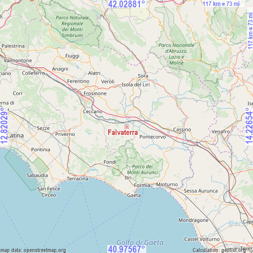
Falvaterra GPS coordinates[2]
41° 30' 15.768" North, 13° 31' 24.276" East
| Map corner | latitude | longitude |
|---|---|---|
| Upper-left | 42.02881°, | 12.82029° |
| Center: | 41.50438°, | 13.52341° |
| Lower-right: | 40.97567°, | 14.22654° |
| Map W x H: | 117.1×117.1 km | = 72.8×72.8mi |
| max Lat: | 47.04031° ⇑74.8% North |
| Falvaterra: | 41.50438° |
| min Lat: | ⇓25.2% South 35.50142° |
| min Long | Falvaterra | max Long |
| 6.69888° | 13.52341° | 18.48682° |
| W 73.8%⇐ | ⇒26.2% E |
Elevation
Elevation of Falvaterra is 296 m = 971 ft, and this is 10.7 m = 35 ft below average elevation for this country.
| Max E: |
2085 m = 6841 ft | 40.5% |
| Avg. | 306.7 m = 1006 ft | |
| Falvaterra | 296 m = 971 ft | |
Min E: |
-4 m = -13 ft | 59.5% |
See also: Italy elevation on elevation.city.
Geographical zone
Falvaterra is located in North temperate zone (between Tropic of Cancer and the Arctic Circle). Distance of this Northern Tropic circle is 2008.9 km =1248.3 mi to South.| Distance of | km | miles | from Falvaterra |
|---|---|---|---|
| North Pole | 5392.2 | 3350.6 | to North |
| Arctic Circle | 2786.3 | 1731.3 | to North |
| Tropic Cancer | 2008.9 | 1248.3 | to South |
| Equator | 4614.9 | 2867.6 | to South |


Nearby cities:
15 places around Falvaterra: (largest is in red/bold)
• Arce
9.7 km =6 mi,  32°
32°
• Castro dei Volsci
9.8 km =6.1 mi,  272°
272°
• Ceprano
4.7 km =2.9 mi,  351°
351°
• Coldragone
8.7 km =5.4 mi,  50°
50°
• Colli
11.2 km =7 mi,  4°
4°
• Madonna del Piano
10 km =6.2 mi,  277°
277°
• Pastena
4.8 km =3 mi,  213°
213°
• Pico
6.7 km =4.2 mi,  153°
153°
• Pofi
11.3 km =7 mi,  306°
306°
• Rocca d'Arce
10.5 km =6.5 mi, 29°
• Roccasecca Stazione
11 km =6.8 mi,  73°
73°
• San Giovanni Incarico
3 km =1.9 mi,  99°
99°
• Strangolagalli
10.9 km =6.8 mi, 346°
• Vallecorsa
11.9 km =7.4 mi,  235°
235°
• Villa Felice
9.7 km =6 mi, 54°
Sources, notices
• [Note1] Compared only with cities in Italy existing in our database
• [Src1] Map data: © OpenStreetMap contributors (CC-BY-SA)
• [Src2] Other city data from geonames.org with taken over terms of usage.
• [Src3] Geographical zone / Annual Mean Temperature by Robert A. Rohde @ Wikipedia
