Monticelli geodata
Monticelli (Latium) is a populated place; located in Italy in Europe/Rome (GMT+2) time zone. With population of 503 people, there are 9902 cities with bigger population in this country. Compared to other cities in Italy, 75.4% of cities are located further ↑North; 75.2% of cities are located further ←West and 72% of cities have higher elevation than Monticelli. Note1


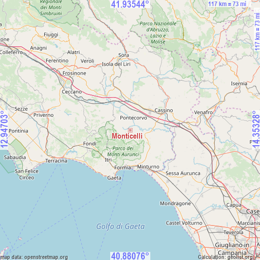
Monticelli GPS coordinates[2]
41° 24' 36.864" North, 13° 39' 0.54" East
| Map corner | latitude | longitude |
|---|---|---|
| Upper-left | 41.93544°, | 12.94703° |
| Center: | 41.41024°, | 13.65015° |
| Lower-right: | 40.88076°, | 14.35328° |
| Map W x H: | 117.3×117.3 km | = 72.9×72.9mi |
| max Lat: | 47.04031° ⇑75.4% North |
| Monticelli: | 41.41024° |
| min Lat: | ⇓24.6% South 35.50142° |
| min Long | Monticelli | max Long |
| 6.69888° | 13.65015° | 18.48682° |
| W 75.2%⇐ | ⇒24.8% E |
Elevation
Elevation of Monticelli is 88 m = 289 ft, and this is 218.7 m = 718 ft below average elevation for this country.
| Max E: |
2085 m = 6841 ft | 72% |
| Avg. | 306.7 m = 1006 ft | |
| Monticelli | 88 m = 289 ft | |
Min E: |
-4 m = -13 ft | 28% |
See also: Italy elevation on elevation.city.
Geographical zone
Monticelli is located in North temperate zone (between Tropic of Cancer and the Arctic Circle). Distance of this Northern Tropic circle is 1998.5 km =1241.8 mi to South.| Distance of | km | miles | from Monticelli |
|---|---|---|---|
| North Pole | 5402.7 | 3357.1 | to North |
| Arctic Circle | 2796.8 | 1737.9 | to North |
| Tropic Cancer | 1998.5 | 1241.8 | to South |
| Equator | 4604.4 | 2861 | to South |


Nearby cities:
15 places around Monticelli: (largest is in red/bold)
• Aquino
10.4 km =6.5 mi,  26°
26°
• Ausonia
10.1 km =6.3 mi,  124°
124°
• Campodimele
10.3 km =6.4 mi,  256°
256°
• Casali
9.4 km =5.8 mi,  112°
112°
• Castelnuovo Parano
9.5 km =5.9 mi, 111°
• Coreno Ausonio
12.6 km =7.8 mi, 123°
• Esperia
4.2 km =2.6 mi,  136°
136°
• Pico
8.8 km =5.5 mi,  300°
300°
• Piedimonte San Germano
12.8 km =8 mi,  40°
40°
• Pignataro Interamna
11.8 km =7.3 mi,  74°
74°
• Pontecorvo
5.5 km =3.4 mi,  13°
13°
• San Giorgio a Liri
9.2 km =5.7 mi,  93°
93°
• San Giovanni Incarico
12.6 km =7.8 mi,  322°
322°
• Spigno Saturnia Inferiore
13.2 km =8.2 mi,  146°
146°
• Spigno Saturnia Superiore
11.7 km =7.3 mi,  155°
155°
Sources, notices
• [Note1] Compared only with cities in Italy existing in our database
• [Src1] Map data: © OpenStreetMap contributors (CC-BY-SA)
• [Src2] Other city data from geonames.org with taken over terms of usage.
• [Src3] Geographical zone / Annual Mean Temperature by Robert A. Rohde @ Wikipedia
