Pianiga geodata
Pianiga (Veneto) is a seat of a third-order administrative division; located in Italy in Europe/Rome (GMT+2) time zone. With population of 6,169 people, there are 1593 cities with bigger population in this country. Compared to other cities in Italy, 72.1% of cities are located further ↓South; 56% of cities are located further ←West and 96.6% of cities have higher elevation than Pianiga. Note1


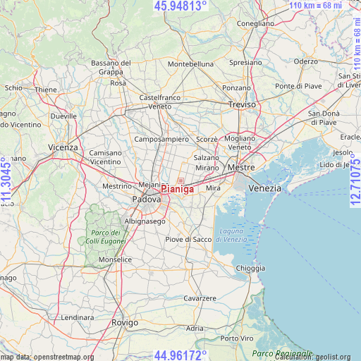
Pianiga GPS coordinates[2]
45° 27' 25.488" North, 12° 0' 27.432" East
| Map corner | latitude | longitude |
|---|---|---|
| Upper-left | 45.94813°, | 11.3045° |
| Center: | 45.45708°, | 12.00762° |
| Lower-right: | 44.96172°, | 12.71075° |
| Map W x H: | 109.7×109.7 km | = 68.2×68.2mi |
| max Lat: | 47.04031° ⇑27.9% North |
| Pianiga: | 45.45708° |
| min Lat: | ⇓72.1% South 35.50142° |
| min Long | Pianiga | max Long |
| 6.69888° | 12.00762° | 18.48682° |
| W 56%⇐ | ⇒44% E |
Elevation
Elevation of Pianiga is 6 m = 20 ft, and this is 300.7 m = 987 ft below average elevation for this country.
| Max E: |
2085 m = 6841 ft | 96.6% |
| Avg. | 306.7 m = 1006 ft | |
| Pianiga | 6 m = 20 ft | |
Min E: |
-4 m = -13 ft | 3.4% |
See also: Italy elevation on elevation.city.
Geographical zone
Pianiga is located in North temperate zone (between Tropic of Cancer and the Arctic Circle). Distance of this North polar circle is 2346.8 km =1458.2 mi to North.| Distance of | km | miles | from Pianiga |
|---|---|---|---|
| North Pole | 4952.7 | 3077.5 | to North |
| Arctic Circle | 2346.8 | 1458.2 | to North |
| Tropic Cancer | 2448.4 | 1521.4 | to South |
| Equator | 5054.4 | 3140.7 | to South |


Nearby cities:
15 places around Pianiga: (largest is in red/bold)
• Arino
4.2 km =2.6 mi,  119°
119°
• Ballò
5 km =3.1 mi,  91°
91°
• Caltana
3.3 km =2.1 mi,  31°
31°
• Caselle
3.2 km =2 mi,  357°
357°
• Cazzago-Ex Polo
5.5 km =3.4 mi,  108°
108°
• Codiverno
5.3 km =3.3 mi,  293°
293°
• Fiesso
4.6 km =2.9 mi,  153°
153°
• Fiesso d'Artico
4.3 km =2.7 mi,  156°
156°
• Oltre Brenta
5.1 km =3.2 mi,  188°
188°
• Pionca
3.7 km =2.3 mi, 285°
• San Vito
5.5 km =3.4 mi,  219°
219°
• Scaltenigo
5.9 km =3.7 mi,  74°
74°
• Stra
5.1 km =3.2 mi,  174°
174°
• Vigonza
3.6 km =2.2 mi,  226°
226°
• Villanova
4.4 km =2.7 mi,  324°
324°
Sources, notices
• [Note1] Compared only with cities in Italy existing in our database
• [Src1] Map data: © OpenStreetMap contributors (CC-BY-SA)
• [Src2] Other city data from geonames.org with taken over terms of usage.
• [Src3] Geographical zone / Annual Mean Temperature by Robert A. Rohde @ Wikipedia
