Vigonza geodata
Vigonza (Veneto) is a seat of a third-order administrative division; located in Italy in Europe/Rome (GMT+2) time zone. With population of 13,798 people, there are 656 cities with bigger population in this country. Compared to other cities in Italy, 71.4% of cities are located further ↓South; 55.5% of cities are located further ←West and 97.8% of cities have higher elevation than Vigonza. Note1


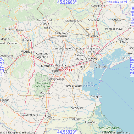
Vigonza GPS coordinates[2]
45° 26' 5.424" North, 11° 58' 28.74" East
| Map corner | latitude | longitude |
|---|---|---|
| Upper-left | 45.92608°, | 11.27153° |
| Center: | 45.43484°, | 11.97465° |
| Lower-right: | 44.93929°, | 12.67778° |
| Map W x H: | 109.7×109.7 km | = 68.2×68.2mi |
| max Lat: | 47.04031° ⇑28.6% North |
| Vigonza: | 45.43484° |
| min Lat: | ⇓71.4% South 35.50142° |
| min Long | Vigonza | max Long |
| 6.69888° | 11.97465° | 18.48682° |
| W 55.5%⇐ | ⇒44.5% E |
Elevation
Elevation of Vigonza is 4 m = 13 ft, and this is 302.7 m = 993 ft below average elevation for this country.
| Max E: |
2085 m = 6841 ft | 97.8% |
| Avg. | 306.7 m = 1006 ft | |
| Vigonza | 4 m = 13 ft | |
Min E: |
-4 m = -13 ft | 2.2% |
See also: Italy elevation on elevation.city.
Geographical zone
Vigonza is located in North temperate zone (between Tropic of Cancer and the Arctic Circle). Distance of this North polar circle is 2349.3 km =1459.8 mi to North.| Distance of | km | miles | from Vigonza |
|---|---|---|---|
| North Pole | 4955.2 | 3079 | to North |
| Arctic Circle | 2349.3 | 1459.8 | to North |
| Tropic Cancer | 2446 | 1519.9 | to South |
| Equator | 5051.9 | 3139.1 | to South |


Nearby cities:
15 places around Vigonza: (largest is in red/bold)
• Cadoneghe
3.8 km =2.4 mi,  283°
283°
• Codiverno
5.1 km =3.2 mi,  333°
333°
• Fiesso
4.9 km =3 mi,  110°
110°
• Fiesso d'Artico
4.5 km =2.8 mi, 109°
• Mejaniga
5.9 km =3.7 mi,  295°
295°
• Noventa
2.9 km =1.8 mi,  218°
218°
• Oltre Brenta
3.1 km =1.9 mi,  144°
144°
• Pianiga
3.6 km =2.2 mi,  46°
46°
• Pionca
3.6 km =2.2 mi,  344°
344°
• San Vito
2 km =1.2 mi,  208°
208°
• Stra
4.1 km =2.5 mi,  130°
130°
• Tombelle
4.1 km =2.5 mi,  171°
171°
• Vigonovo
5.9 km =3.7 mi,  155°
155°
• Villanova
6 km =3.7 mi,  0°
0°
• Villatora
5.3 km =3.3 mi,  186°
186°
Sources, notices
• [Note1] Compared only with cities in Italy existing in our database
• [Src1] Map data: © OpenStreetMap contributors (CC-BY-SA)
• [Src2] Other city data from geonames.org with taken over terms of usage.
• [Src3] Geographical zone / Annual Mean Temperature by Robert A. Rohde @ Wikipedia
