Stra geodata
Stra (Veneto) is a seat of a third-order administrative division; located in Italy in Europe/Rome (GMT+2) time zone. With population of 6,200 people, there are 1580 cities with bigger population in this country. Compared to other cities in Italy, 70.6% of cities are located further ↓South; 56.1% of cities are located further ←West and 95.3% of cities have higher elevation than Stra. Note1


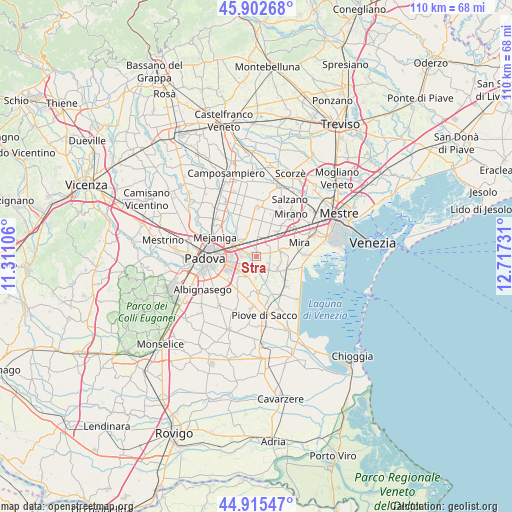
Stra GPS coordinates[2]
45° 24' 40.428" North, 12° 0' 51.048" East
| Map corner | latitude | longitude |
|---|---|---|
| Upper-left | 45.90268°, | 11.31106° |
| Center: | 45.41123°, | 12.01418° |
| Lower-right: | 44.91547°, | 12.71731° |
| Map W x H: | 109.8×109.8 km | = 68.2×68.2mi |
| max Lat: | 47.04031° ⇑29.4% North |
| Stra: | 45.41123° |
| min Lat: | ⇓70.6% South 35.50142° |
| min Long | Stra | max Long |
| 6.69888° | 12.01418° | 18.48682° |
| W 56.1%⇐ | ⇒43.9% E |
Elevation
Elevation of Stra is 8 m = 26 ft, and this is 298.7 m = 980 ft below average elevation for this country.
| Max E: |
2085 m = 6841 ft | 95.3% |
| Avg. | 306.7 m = 1006 ft | |
| Stra | 8 m = 26 ft | |
Min E: |
-4 m = -13 ft | 4.7% |
See also: Italy elevation on elevation.city.
Geographical zone
Stra is located in North temperate zone (between Tropic of Cancer and the Arctic Circle). Distance of this North polar circle is 2351.9 km =1461.4 mi to North.| Distance of | km | miles | from Stra |
|---|---|---|---|
| North Pole | 4957.8 | 3080.6 | to North |
| Arctic Circle | 2351.9 | 1461.4 | to North |
| Tropic Cancer | 2443.3 | 1518.2 | to South |
| Equator | 5049.3 | 3137.5 | to South |


Nearby cities:
15 places around Stra: (largest is in red/bold)
• Arino
4.4 km =2.7 mi,  45°
45°
• Brigo-Paluello
2.9 km =1.8 mi,  91°
91°
• Fiesso
1.8 km =1.1 mi,  58°
58°
• Fiesso d'Artico
1.6 km =1 mi, 46°
• Fossò
3.8 km =2.4 mi,  138°
138°
• Galta
2.4 km =1.5 mi,  162°
162°
• Noventa
4.9 km =3 mi,  273°
273°
• Oltre Brenta
1.3 km =0.8 mi, 274°
• Pianiga
5.1 km =3.2 mi,  354°
354°
• San Vito
4.1 km =2.5 mi,  281°
281°
• Saonara
5.6 km =3.5 mi,  204°
204°
• Tombelle
2.9 km =1.8 mi,  240°
240°
• Vigonovo
2.8 km =1.7 mi,  192°
192°
• Vigonza
4.1 km =2.5 mi,  310°
310°
• Villatora
4.5 km =2.8 mi,  234°
234°
Sources, notices
• [Note1] Compared only with cities in Italy existing in our database
• [Src1] Map data: © OpenStreetMap contributors (CC-BY-SA)
• [Src2] Other city data from geonames.org with taken over terms of usage.
• [Src3] Geographical zone / Annual Mean Temperature by Robert A. Rohde @ Wikipedia
