Ceriana geodata
Ceriana (Liguria) is a seat of a third-order administrative division; located in Italy in Europe/Rome (GMT+2) time zone. With population of 915 people, there are 7064 cities with bigger population in this country. Compared to other cities in Italy, 55.9% of cities are located further ↑North; 95.8% of cities are located further →East and 65.7% of cities have lower elevation than Ceriana. Note1


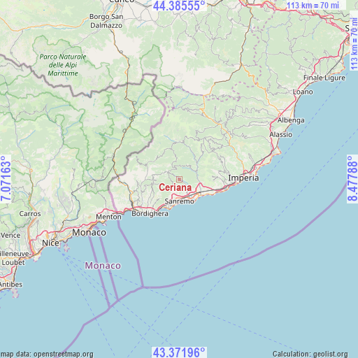
Ceriana GPS coordinates[2]
43° 52' 51.276" North, 7° 46' 29.136" East
| Map corner | latitude | longitude |
|---|---|---|
| Upper-left | 44.38555°, | 7.07163° |
| Center: | 43.88091°, | 7.77476° |
| Lower-right: | 43.37196°, | 8.47788° |
| Map W x H: | 112.7×112.7 km | = 70×70mi |
| max Lat: | 47.04031° ⇑55.9% North |
| Ceriana: | 43.88091° |
| min Lat: | ⇓44.1% South 35.50142° |
| min Long | Ceriana | max Long |
| 6.69888° | 7.77476° | 18.48682° |
| W 4.2%⇐ | ⇒95.8% E |
Elevation
Elevation of Ceriana is 350 m = 1148 ft, and this is 43.3 m = 142 ft above average elevation for this country.
| Max E: |
2085 m = 6841 ft | 34.3% |
| Ceriana | 350 m 1148 ft | |
| Avg. | 306.7 m = 1006 ft | |
Min E: |
-4 m = -13 ft | 65.7% |
See also: Italy elevation on elevation.city.
Geographical zone
Ceriana is located in North temperate zone (between Tropic of Cancer and the Arctic Circle). Distance of this Northern Tropic circle is 2273.2 km =1412.5 mi to South.| Distance of | km | miles | from Ceriana |
|---|---|---|---|
| North Pole | 5128 | 3186.4 | to North |
| Arctic Circle | 2522.1 | 1567.2 | to North |
| Tropic Cancer | 2273.2 | 1412.5 | to South |
| Equator | 4879.1 | 3031.7 | to South |


Nearby cities:
15 places around Ceriana: (largest is in red/bold)
• Apricale
9.2 km =5.7 mi,  269°
269°
• Badalucco
7 km =4.3 mi,  54°
54°
• Bajardo
4.7 km =2.9 mi,  302°
302°
• Castel Vittorio
9.5 km =5.9 mi, 302°
• Castellaro
7.8 km =4.8 mi,  103°
103°
• Montalto Ligure
7.7 km =4.8 mi, 46°
• Ospedaletti
9.9 km =6.2 mi,  207°
207°
• Perinaldo
8.4 km =5.2 mi,  259°
259°
• Pietrabruna
10.3 km =6.4 mi,  84°
84°
• Pompeiana
9.6 km =6 mi,  108°
108°
• Riva Ligure
9.6 km =6 mi,  119°
119°
• San Remo
7.1 km =4.4 mi,  178°
178°
• Seborga
8.7 km =5.4 mi,  226°
226°
• Taggia
7.3 km =4.5 mi, 121°
• Terzorio
10.4 km =6.5 mi, 107°
Sources, notices
• [Note1] Compared only with cities in Italy existing in our database
• [Src1] Map data: © OpenStreetMap contributors (CC-BY-SA)
• [Src2] Other city data from geonames.org with taken over terms of usage.
• [Src3] Geographical zone / Annual Mean Temperature by Robert A. Rohde @ Wikipedia
