Percoto geodata
Percoto (Friuli Venezia Giulia) is a populated place; located in Italy in Europe/Rome (GMT+2) time zone. With population of 1,542 people, there are 5032 cities with bigger population in this country. Compared to other cities in Italy, 91.3% of cities are located further ↓South; 71.6% of cities are located further ←West and 78.3% of cities have higher elevation than Percoto. Note1
Administrative division(s):
- Level 1: Friuli Venezia Giulia
- Level 2: Provincia di Udine
- Level 3: Pavia di Udine


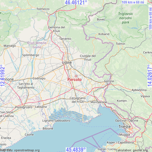
Percoto GPS coordinates[2]
45° 58' 28.956" North, 13° 19' 22.944" East
| Map corner | latitude | longitude |
|---|---|---|
| Upper-left | 46.46121°, | 12.61992° |
| Center: | 45.97471°, | 13.32304° |
| Lower-right: | 45.4839°, | 14.02617° |
| Map W x H: | 108.7×108.7 km | = 67.5×67.5mi |
| max Lat: | 47.04031° ⇑8.7% North |
| Percoto: | 45.97471° |
| min Lat: | ⇓91.3% South 35.50142° |
| min Long | Percoto | max Long |
| 6.69888° | 13.32304° | 18.48682° |
| W 71.6%⇐ | ⇒28.4% E |
Elevation
Elevation of Percoto is 58 m = 190 ft, and this is 248.7 m = 816 ft below average elevation for this country.
| Max E: |
2085 m = 6841 ft | 78.3% |
| Avg. | 306.7 m = 1006 ft | |
| Percoto | 58 m = 190 ft | |
Min E: |
-4 m = -13 ft | 21.7% |
See also: Italy elevation on elevation.city.
Geographical zone
Percoto is located in North temperate zone (between Tropic of Cancer and the Arctic Circle). Distance of this North polar circle is 2289.3 km =1422.5 mi to North.| Distance of | km | miles | from Percoto |
|---|---|---|---|
| North Pole | 4895.2 | 3041.7 | to North |
| Arctic Circle | 2289.3 | 1422.5 | to North |
| Tropic Cancer | 2506 | 1557.2 | to South |
| Equator | 5111.9 | 3176.4 | to South |


Nearby cities:
15 places around Percoto: (largest is in red/bold)
• Bicinicco
7.2 km =4.5 mi,  228°
228°
• Buttrio
4.1 km =2.5 mi,  11°
11°
• Ialmicco
7.1 km =4.4 mi,  165°
165°
• Lauzacco
3.4 km =2.1 mi,  282°
282°
• Lumignacco
6.5 km =4 mi,  293°
293°
• Manzano
4.4 km =2.7 mi,  69°
69°
• Medeuzza
6.8 km =4.2 mi,  123°
123°
• Pavia di Udine
2.7 km =1.7 mi,  326°
326°
• Pradamano
6.8 km =4.2 mi,  346°
346°
• Risano
5.3 km =3.3 mi,  269°
269°
• Sammardenchia
7.3 km =4.5 mi, 279°
• San Giovanni al Natisone
6.1 km =3.8 mi,  94°
94°
• Santa Maria la Longa
5.2 km =3.2 mi,  210°
210°
• Sottoselva
7 km =4.3 mi,  179°
179°
• Trivignano Udinese
3.5 km =2.2 mi,  157°
157°
Sources, notices
• [Note1] Compared only with cities in Italy existing in our database
• [Src1] Map data: © OpenStreetMap contributors (CC-BY-SA)
• [Src2] Other city data from geonames.org with taken over terms of usage.
• [Src3] Geographical zone / Annual Mean Temperature by Robert A. Rohde @ Wikipedia
