Manzano geodata
Manzano (Friuli Venezia Giulia) is a seat of a third-order administrative division; located in Italy in Europe/Rome (GMT+2) time zone. With population of 5,168 people, there are 1890 cities with bigger population in this country. Compared to other cities in Italy, 91.7% of cities are located further ↓South; 72.2% of cities are located further ←West and 76.6% of cities have higher elevation than Manzano. Note1
Administrative division(s):
- Level 1: Friuli Venezia Giulia
- Level 2: Provincia di Udine
- Level 3: Manzano


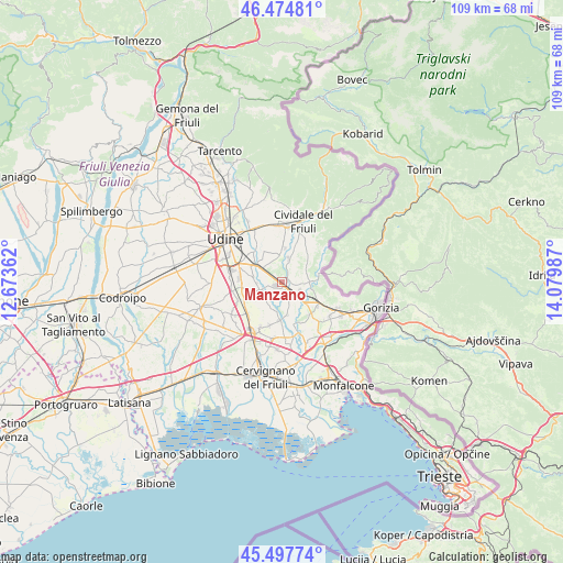
Manzano GPS coordinates[2]
45° 59' 18.348" North, 13° 22' 36.264" East
| Map corner | latitude | longitude |
|---|---|---|
| Upper-left | 46.47481°, | 12.67362° |
| Center: | 45.98843°, | 13.37674° |
| Lower-right: | 45.49774°, | 14.07987° |
| Map W x H: | 108.6×108.6 km | = 67.5×67.5mi |
| max Lat: | 47.04031° ⇑8.3% North |
| Manzano: | 45.98843° |
| min Lat: | ⇓91.7% South 35.50142° |
| min Long | Manzano | max Long |
| 6.69888° | 13.37674° | 18.48682° |
| W 72.2%⇐ | ⇒27.8% E |
Elevation
Elevation of Manzano is 66 m = 217 ft, and this is 240.7 m = 790 ft below average elevation for this country.
| Max E: |
2085 m = 6841 ft | 76.6% |
| Avg. | 306.7 m = 1006 ft | |
| Manzano | 66 m = 217 ft | |
Min E: |
-4 m = -13 ft | 23.4% |
See also: Italy elevation on elevation.city.
Geographical zone
Manzano is located in North temperate zone (between Tropic of Cancer and the Arctic Circle). Distance of this North polar circle is 2287.7 km =1421.5 mi to North.| Distance of | km | miles | from Manzano |
|---|---|---|---|
| North Pole | 4893.6 | 3040.7 | to North |
| Arctic Circle | 2287.7 | 1421.5 | to North |
| Tropic Cancer | 2507.5 | 1558.1 | to South |
| Equator | 5113.4 | 3177.3 | to South |


Nearby cities:
15 places around Manzano: (largest is in red/bold)
• Brazzano
6.2 km =3.9 mi,  103°
103°
• Buttrio
4.2 km =2.6 mi,  306°
306°
• Chiopris
7.2 km =4.5 mi,  162°
162°
• Corno di Rosazzo
5.2 km =3.2 mi,  86°
86°
• Dolegnano
4 km =2.5 mi, 97°
• Ipplis
6.6 km =4.1 mi,  22°
22°
• Lauzacco
7.5 km =4.7 mi,  263°
263°
• Medeuzza
5.5 km =3.4 mi, 163°
• Orsaria
5.6 km =3.5 mi,  4°
4°
• Pavia di Udine
5.7 km =3.5 mi,  277°
277°
• Percoto
4.4 km =2.7 mi,  249°
249°
• Pradamano
7.7 km =4.8 mi, 311°
• San Giovanni al Natisone
2.8 km =1.7 mi,  135°
135°
• Trivignano Udinese
5.5 km =3.4 mi,  210°
210°
• Villanova
5 km =3.1 mi, 138°
Sources, notices
• [Note1] Compared only with cities in Italy existing in our database
• [Src1] Map data: © OpenStreetMap contributors (CC-BY-SA)
• [Src2] Other city data from geonames.org with taken over terms of usage.
• [Src3] Geographical zone / Annual Mean Temperature by Robert A. Rohde @ Wikipedia
