Buttrio geodata
Buttrio (Friuli Venezia Giulia) is a seat of a third-order administrative division; located in Italy in Europe/Rome (GMT+2) time zone. With population of 3,947 people, there are 2422 cities with bigger population in this country. Compared to other cities in Italy, 92.2% of cities are located further ↓South; 71.7% of cities are located further ←West and 75.2% of cities have higher elevation than Buttrio. Note1
Administrative division(s):
- Level 1: Friuli Venezia Giulia
- Level 2: Provincia di Udine
- Level 3: Buttrio


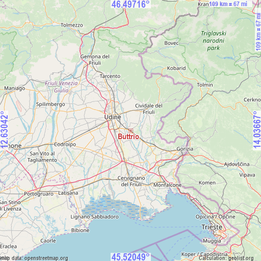
Buttrio GPS coordinates[2]
46° 0' 39.528" North, 13° 20' 0.744" East
| Map corner | latitude | longitude |
|---|---|---|
| Upper-left | 46.49716°, | 12.63042° |
| Center: | 46.01098°, | 13.33354° |
| Lower-right: | 45.52049°, | 14.03667° |
| Map W x H: | 108.6×108.6 km | = 67.5×67.5mi |
| max Lat: | 47.04031° ⇑7.8% North |
| Buttrio: | 46.01098° |
| min Lat: | ⇓92.2% South 35.50142° |
| min Long | Buttrio | max Long |
| 6.69888° | 13.33354° | 18.48682° |
| W 71.7%⇐ | ⇒28.3% E |
Elevation
Elevation of Buttrio is 73 m = 240 ft, and this is 233.7 m = 767 ft below average elevation for this country.
| Max E: |
2085 m = 6841 ft | 75.2% |
| Avg. | 306.7 m = 1006 ft | |
| Buttrio | 73 m = 240 ft | |
Min E: |
-4 m = -13 ft | 24.8% |
See also: Italy elevation on elevation.city.
Geographical zone
Buttrio is located in North temperate zone (between Tropic of Cancer and the Arctic Circle). Distance of this North polar circle is 2285.2 km =1420 mi to North.| Distance of | km | miles | from Buttrio |
|---|---|---|---|
| North Pole | 4891.1 | 3039.2 | to North |
| Arctic Circle | 2285.2 | 1420 | to North |
| Tropic Cancer | 2510 | 1559.6 | to South |
| Equator | 5115.9 | 3178.9 | to South |


Nearby cities:
15 places around Buttrio: (largest is in red/bold)
• Cargnacco
7.6 km =4.7 mi,  264°
264°
• Cerneglons
5 km =3.1 mi,  338°
338°
• Ipplis
6.9 km =4.3 mi,  58°
58°
• Lauzacco
5.3 km =3.3 mi,  231°
231°
• Lumignacco
6.9 km =4.3 mi, 258°
• Manzano
4.2 km =2.6 mi,  126°
126°
• Orsaria
4.9 km =3 mi,  50°
50°
• Orzano
6.2 km =3.9 mi,  8°
8°
• Pavia di Udine
2.9 km =1.8 mi, 232°
• Percoto
4.1 km =2.5 mi,  191°
191°
• Pradamano
3.5 km =2.2 mi,  316°
316°
• Premariacco
7.3 km =4.5 mi,  40°
40°
• Risano
7.3 km =4.5 mi,  236°
236°
• San Giovanni al Natisone
6.9 km =4.3 mi, 130°
• Trivignano Udinese
7.2 km =4.5 mi,  175°
175°
Sources, notices
• [Note1] Compared only with cities in Italy existing in our database
• [Src1] Map data: © OpenStreetMap contributors (CC-BY-SA)
• [Src2] Other city data from geonames.org with taken over terms of usage.
• [Src3] Geographical zone / Annual Mean Temperature by Robert A. Rohde @ Wikipedia
