Pellezzano geodata
Pellezzano (Campania) is a seat of a third-order administrative division; located in Italy in Europe/Rome (GMT+2) time zone. With population of 1,243 people, there are 5817 cities with bigger population in this country. Compared to other cities in Italy, 82.2% of cities are located further ↑North; 85% of cities are located further ←West and 51.2% of cities have lower elevation than Pellezzano. Note1


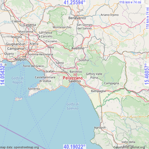
Pellezzano GPS coordinates[2]
40° 43' 30.756" North, 14° 45' 26.784" East
| Map corner | latitude | longitude |
|---|---|---|
| Upper-left | 41.25594°, | 14.05432° |
| Center: | 40.72521°, | 14.75744° |
| Lower-right: | 40.19022°, | 15.46057° |
| Map W x H: | 118.5×118.5 km | = 73.6×73.6mi |
| max Lat: | 47.04031° ⇑82.2% North |
| Pellezzano: | 40.72521° |
| min Lat: | ⇓17.8% South 35.50142° |
| min Long | Pellezzano | max Long |
| 6.69888° | 14.75744° | 18.48682° |
| W 85%⇐ | ⇒15% E |
Elevation
Elevation of Pellezzano is 242 m = 794 ft, and this is 64.7 m = 212 ft below average elevation for this country.
| Max E: |
2085 m = 6841 ft | 48.8% |
| Avg. | 306.7 m = 1006 ft | |
| Pellezzano | 242 m = 794 ft | |
Min E: |
-4 m = -13 ft | 51.2% |
See also: Italy elevation on elevation.city.
Geographical zone
Pellezzano is located in North temperate zone (between Tropic of Cancer and the Arctic Circle). Distance of this Northern Tropic circle is 1922.3 km =1194.5 mi to South.| Distance of | km | miles | from Pellezzano |
|---|---|---|---|
| North Pole | 5478.8 | 3404.4 | to North |
| Arctic Circle | 2873 | 1785.2 | to North |
| Tropic Cancer | 1922.3 | 1194.5 | to South |
| Equator | 4528.2 | 2813.7 | to South |


Nearby cities:
15 places around Pellezzano: (largest is in red/bold)
• Acquarola
5.5 km =3.4 mi,  330°
330°
• Antessano
1.9 km =1.2 mi,  63°
63°
• Baronissi
2.9 km =1.8 mi,  28°
28°
• Capezzano Inferiore
3 km =1.9 mi,  154°
154°
• Capezzano-Cologna
1.8 km =1.1 mi,  129°
129°
• Caprecano
3.3 km =2.1 mi, 57°
• Capriglia
0.8 km =0.5 mi,  17°
17°
• Cava Dè Tirreni
5.1 km =3.2 mi,  235°
235°
• Coperchia
1 km =0.6 mi, 126°
• Fisciano
6 km =3.7 mi, 31°
• Lancusi-Penta-Bolano
4.6 km =2.9 mi, 30°
• Le Selve
5.8 km =3.6 mi, 19°
• Molina
5.6 km =3.5 mi,  213°
213°
• Sant'Anna I
4 km =2.5 mi,  282°
282°
• Spiano
4.1 km =2.5 mi,  351°
351°
Sources, notices
• [Note1] Compared only with cities in Italy existing in our database
• [Src1] Map data: © OpenStreetMap contributors (CC-BY-SA)
• [Src2] Other city data from geonames.org with taken over terms of usage.
• [Src3] Geographical zone / Annual Mean Temperature by Robert A. Rohde @ Wikipedia
