Coperchia geodata
Coperchia (Campania) is a populated place; located in Italy in Europe/Rome (GMT+2) time zone. With population of 2,768 people, there are 3247 cities with bigger population in this country. Compared to other cities in Italy, 82.2% of cities are located further ↑North; 85.1% of cities are located further ←West and 59.4% of cities have higher elevation than Coperchia. Note1


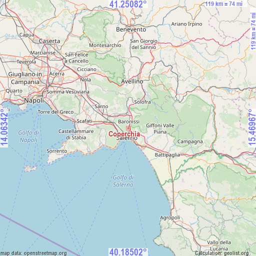
Coperchia GPS coordinates[2]
40° 43' 12.18" North, 14° 45' 59.544" East
| Map corner | latitude | longitude |
|---|---|---|
| Upper-left | 41.25082°, | 14.06342° |
| Center: | 40.72005°, | 14.76654° |
| Lower-right: | 40.18502°, | 15.46967° |
| Map W x H: | 118.5×118.5 km | = 73.6×73.6mi |
| max Lat: | 47.04031° ⇑82.2% North |
| Coperchia: | 40.72005° |
| min Lat: | ⇓17.8% South 35.50142° |
| min Long | Coperchia | max Long |
| 6.69888° | 14.76654° | 18.48682° |
| W 85.1%⇐ | ⇒14.9% E |
Elevation
Elevation of Coperchia is 168 m = 551 ft, and this is 138.7 m = 455 ft below average elevation for this country.
| Max E: |
2085 m = 6841 ft | 59.4% |
| Avg. | 306.7 m = 1006 ft | |
| Coperchia | 168 m = 551 ft | |
Min E: |
-4 m = -13 ft | 40.6% |
See also: Italy elevation on elevation.city.
Geographical zone
Coperchia is located in North temperate zone (between Tropic of Cancer and the Arctic Circle). Distance of this Northern Tropic circle is 1921.7 km =1194.1 mi to South.| Distance of | km | miles | from Coperchia |
|---|---|---|---|
| North Pole | 5479.4 | 3404.7 | to North |
| Arctic Circle | 2873.5 | 1785.5 | to North |
| Tropic Cancer | 1921.7 | 1194.1 | to South |
| Equator | 4527.6 | 2813.3 | to South |


Nearby cities:
15 places around Coperchia: (largest is in red/bold)
• Antessano
1.7 km =1.1 mi,  32°
32°
• Baronissi
3.2 km =2 mi,  11°
11°
• Capezzano Inferiore
2.2 km =1.4 mi,  165°
165°
• Capezzano-Cologna
0.8 km =0.5 mi,  132°
132°
• Caprecano
3.1 km =1.9 mi,  40°
40°
• Capriglia
1.4 km =0.9 mi,  338°
338°
• Cava Dè Tirreni
5.5 km =3.4 mi,  245°
245°
• Gaiano
5.7 km =3.5 mi,  47°
47°
• Lancusi-Penta-Bolano
4.8 km =3 mi,  18°
18°
• Molina
5.6 km =3.5 mi,  223°
223°
• Pellezzano
1 km =0.6 mi,  306°
306°
• Piegolelle-San Bartolomeo
6.1 km =3.8 mi, 128°
• Salerno
5.4 km =3.4 mi,  155°
155°
• Sant'Anna I
4.8 km =3 mi,  287°
287°
• Spiano
4.8 km =3 mi, 343°
Sources, notices
• [Note1] Compared only with cities in Italy existing in our database
• [Src1] Map data: © OpenStreetMap contributors (CC-BY-SA)
• [Src2] Other city data from geonames.org with taken over terms of usage.
• [Src3] Geographical zone / Annual Mean Temperature by Robert A. Rohde @ Wikipedia
