Panni geodata
Panni (Apulia) is a seat of a third-order administrative division; located in Italy in Europe/Rome (GMT+2) time zone. With population of 858 people, there are 7366 cities with bigger population in this country. Compared to other cities in Italy, 76.7% of cities are located further ↑North; 89.4% of cities are located further ←West and 90.5% of cities have lower elevation than Panni. Note1


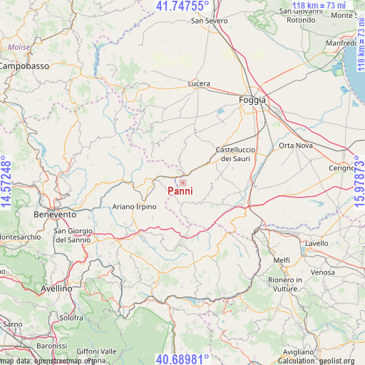
Panni GPS coordinates[2]
41° 13' 14.952" North, 15° 16' 32.16" East
| Map corner | latitude | longitude |
|---|---|---|
| Upper-left | 41.74755°, | 14.57248° |
| Center: | 41.22082°, | 15.2756° |
| Lower-right: | 40.68981°, | 15.97873° |
| Map W x H: | 117.6×117.6 km | = 73.1×73.1mi |
| max Lat: | 47.04031° ⇑76.7% North |
| Panni: | 41.22082° |
| min Lat: | ⇓23.3% South 35.50142° |
| min Long | Panni | max Long |
| 6.69888° | 15.2756° | 18.48682° |
| W 89.4%⇐ | ⇒10.6% E |
Elevation
Elevation of Panni is 731 m = 2398 ft, and this is 424.3 m = 1392 ft above average elevation for this country.
| Max E: |
2085 m = 6841 ft | 9.5% |
| Panni | 731 m 2398 ft | |
| Avg. | 306.7 m = 1006 ft | |
Min E: |
-4 m = -13 ft | 90.5% |
See also: Italy elevation on elevation.city.
Geographical zone
Panni is located in North temperate zone (between Tropic of Cancer and the Arctic Circle). Distance of this Northern Tropic circle is 1977.4 km =1228.7 mi to South.| Distance of | km | miles | from Panni |
|---|---|---|---|
| North Pole | 5423.7 | 3370.1 | to North |
| Arctic Circle | 2817.8 | 1750.9 | to North |
| Tropic Cancer | 1977.4 | 1228.7 | to South |
| Equator | 4583.3 | 2847.9 | to South |


Nearby cities:
15 places around Panni: (largest is in red/bold)
• Accadia
8.4 km =5.2 mi,  146°
146°
• Anzano di Puglia
11.1 km =6.9 mi,  175°
175°
• Bovino
6.2 km =3.9 mi,  59°
59°
• Celle di San Vito
14.1 km =8.8 mi,  325°
325°
• Deliceto
9.1 km =5.7 mi,  88°
88°
• Faeto
15 km =9.3 mi,  320°
320°
• Greci
9.5 km =5.9 mi,  291°
291°
• Montaguto
3.8 km =2.4 mi, 323°
• Monteleone di Puglia
6.1 km =3.8 mi,  193°
193°
• Orsara di Puglia
6.8 km =4.2 mi,  354°
354°
• Sant'Agata di Puglia
11.6 km =7.2 mi,  131°
131°
• Savignano Irpino
8.1 km =5 mi,  274°
274°
• Scampitella
14.4 km =8.9 mi,  171°
171°
• Villanova del Battista
15 km =9.3 mi,  220°
220°
• Zungoli
12 km =7.5 mi,  210°
210°
Sources, notices
• [Note1] Compared only with cities in Italy existing in our database
• [Src1] Map data: © OpenStreetMap contributors (CC-BY-SA)
• [Src2] Other city data from geonames.org with taken over terms of usage.
• [Src3] Geographical zone / Annual Mean Temperature by Robert A. Rohde @ Wikipedia
