Accadia geodata
Accadia (Apulia) is a seat of a third-order administrative division; located in Italy in Europe/Rome (GMT+2) time zone. With population of 2,262 people, there are 3804 cities with bigger population in this country. Compared to other cities in Italy, 77.2% of cities are located further ↑North; 89.8% of cities are located further ←West and 87.1% of cities have lower elevation than Accadia. Note1


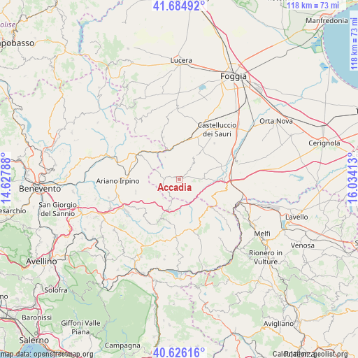
Accadia GPS coordinates[2]
41° 9' 27.648" North, 15° 19' 51.6" East
| Map corner | latitude | longitude |
|---|---|---|
| Upper-left | 41.68492°, | 14.62788° |
| Center: | 41.15768°, | 15.331° |
| Lower-right: | 40.62616°, | 16.03413° |
| Map W x H: | 117.7×117.7 km | = 73.1×73.1mi |
| max Lat: | 47.04031° ⇑77.2% North |
| Accadia: | 41.15768° |
| min Lat: | ⇓22.8% South 35.50142° |
| min Long | Accadia | max Long |
| 6.69888° | 15.331° | 18.48682° |
| W 89.8%⇐ | ⇒10.2% E |
Elevation
Elevation of Accadia is 652 m = 2139 ft, and this is 345.3 m = 1133 ft above average elevation for this country.
| Max E: |
2085 m = 6841 ft | 12.9% |
| Accadia | 652 m 2139 ft | |
| Avg. | 306.7 m = 1006 ft | |
Min E: |
-4 m = -13 ft | 87.1% |
See also: Italy elevation on elevation.city.
Geographical zone
Accadia is located in North temperate zone (between Tropic of Cancer and the Arctic Circle). Distance of this Northern Tropic circle is 1970.4 km =1224.3 mi to South.| Distance of | km | miles | from Accadia |
|---|---|---|---|
| North Pole | 5430.8 | 3374.5 | to North |
| Arctic Circle | 2824.9 | 1755.3 | to North |
| Tropic Cancer | 1970.4 | 1224.3 | to South |
| Equator | 4576.3 | 2843.6 | to South |


Nearby cities:
15 places around Accadia: (largest is in red/bold)
• Anzano di Puglia
5.5 km =3.4 mi,  222°
222°
• Bovino
10.2 km =6.3 mi,  3°
3°
• Deliceto
8.5 km =5.3 mi,  31°
31°
• Lacedonia
14.2 km =8.8 mi,  147°
147°
• Montaguto
12.3 km =7.6 mi,  325°
325°
• Monteleone di Puglia
6.2 km =3.9 mi,  279°
279°
• Panni
8.4 km =5.2 mi, 326°
• Rocchetta Sant'Antonio
12.4 km =7.7 mi,  119°
119°
• San Sossio Baronia
14.5 km =9 mi,  228°
228°
• Sant'Agata di Puglia
4.1 km =2.5 mi,  99°
99°
• Scampitella
7.7 km =4.8 mi,  199°
199°
• Trevico
14.7 km =9.1 mi,  213°
213°
• Vallata
14.6 km =9.1 mi, 206°
• Vallesaccarda
12.4 km =7.7 mi, 212°
• Zungoli
11.3 km =7 mi,  252°
252°
Sources, notices
• [Note1] Compared only with cities in Italy existing in our database
• [Src1] Map data: © OpenStreetMap contributors (CC-BY-SA)
• [Src2] Other city data from geonames.org with taken over terms of usage.
• [Src3] Geographical zone / Annual Mean Temperature by Robert A. Rohde @ Wikipedia
