Deliceto geodata
Deliceto (Apulia) is a seat of a third-order administrative division; located in Italy in Europe/Rome (GMT+2) time zone. With population of 3,660 people, there are 2578 cities with bigger population in this country. Compared to other cities in Italy, 76.7% of cities are located further ↑North; 90.2% of cities are located further ←West and 84.5% of cities have lower elevation than Deliceto. Note1


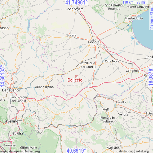
Deliceto GPS coordinates[2]
41° 13' 22.404" North, 15° 23' 4.092" East
| Map corner | latitude | longitude |
|---|---|---|
| Upper-left | 41.74961°, | 14.68135° |
| Center: | 41.22289°, | 15.38447° |
| Lower-right: | 40.6919°, | 16.0876° |
| Map W x H: | 117.6×117.6 km | = 73.1×73.1mi |
| max Lat: | 47.04031° ⇑76.7% North |
| Deliceto: | 41.22289° |
| min Lat: | ⇓23.3% South 35.50142° |
| min Long | Deliceto | max Long |
| 6.69888° | 15.38447° | 18.48682° |
| W 90.2%⇐ | ⇒9.8% E |
Elevation
Elevation of Deliceto is 600 m = 1969 ft, and this is 293.3 m = 962 ft above average elevation for this country.
| Max E: |
2085 m = 6841 ft | 15.5% |
| Deliceto | 600 m 1969 ft | |
| Avg. | 306.7 m = 1006 ft | |
Min E: |
-4 m = -13 ft | 84.5% |
See also: Italy elevation on elevation.city.
Geographical zone
Deliceto is located in North temperate zone (between Tropic of Cancer and the Arctic Circle). Distance of this Northern Tropic circle is 1977.6 km =1228.8 mi to South.| Distance of | km | miles | from Deliceto |
|---|---|---|---|
| North Pole | 5423.5 | 3370 | to North |
| Arctic Circle | 2817.6 | 1750.8 | to North |
| Tropic Cancer | 1977.6 | 1228.8 | to South |
| Equator | 4583.6 | 2848.1 | to South |


Nearby cities:
15 places around Deliceto: (largest is in red/bold)
• Accadia
8.5 km =5.3 mi,  211°
211°
• Anzano di Puglia
13.9 km =8.6 mi,  215°
215°
• Ascoli Satriano
15.4 km =9.6 mi,  97°
97°
• Bovino
4.8 km =3 mi,  307°
307°
• Candela
14.6 km =9.1 mi,  131°
131°
• Castelluccio dei Sauri
11.9 km =7.4 mi,  39°
39°
• Montaguto
11.7 km =7.3 mi,  284°
284°
• Monteleone di Puglia
12.2 km =7.6 mi,  239°
239°
• Orsara di Puglia
11.7 km =7.3 mi,  303°
303°
• Panni
9.1 km =5.7 mi,  268°
268°
• Rocchetta Sant'Antonio
14.7 km =9.1 mi,  154°
154°
• Sant'Agata di Puglia
8 km =5 mi,  182°
182°
• Savignano Irpino
17.2 km =10.7 mi, 271°
• Scampitella
16.1 km =10 mi, 206°
• Troia
16.7 km =10.4 mi,  340°
340°
Sources, notices
• [Note1] Compared only with cities in Italy existing in our database
• [Src1] Map data: © OpenStreetMap contributors (CC-BY-SA)
• [Src2] Other city data from geonames.org with taken over terms of usage.
• [Src3] Geographical zone / Annual Mean Temperature by Robert A. Rohde @ Wikipedia
