Bovino geodata
Bovino (Apulia) is a seat of a third-order administrative division; located in Italy in Europe/Rome (GMT+2) time zone. With population of 3,335 people, there are 2814 cities with bigger population in this country. Compared to other cities in Italy, 76.5% of cities are located further ↑North; 89.8% of cities are located further ←West and 84.5% of cities have lower elevation than Bovino. Note1


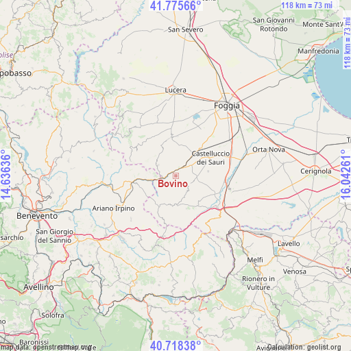
Bovino GPS coordinates[2]
41° 14' 56.976" North, 15° 20' 22.128" East
| Map corner | latitude | longitude |
|---|---|---|
| Upper-left | 41.77566°, | 14.63636° |
| Center: | 41.24916°, | 15.33948° |
| Lower-right: | 40.71838°, | 16.04261° |
| Map W x H: | 117.6×117.6 km | = 73.1×73.1mi |
| max Lat: | 47.04031° ⇑76.5% North |
| Bovino: | 41.24916° |
| min Lat: | ⇓23.5% South 35.50142° |
| min Long | Bovino | max Long |
| 6.69888° | 15.33948° | 18.48682° |
| W 89.8%⇐ | ⇒10.2% E |
Elevation
Elevation of Bovino is 601 m = 1972 ft, and this is 294.3 m = 966 ft above average elevation for this country.
| Max E: |
2085 m = 6841 ft | 15.5% |
| Bovino | 601 m 1972 ft | |
| Avg. | 306.7 m = 1006 ft | |
Min E: |
-4 m = -13 ft | 84.5% |
See also: Italy elevation on elevation.city.
Geographical zone
Bovino is located in North temperate zone (between Tropic of Cancer and the Arctic Circle). Distance of this Northern Tropic circle is 1980.6 km =1230.7 mi to South.| Distance of | km | miles | from Bovino |
|---|---|---|---|
| North Pole | 5420.6 | 3368.2 | to North |
| Arctic Circle | 2814.7 | 1749 | to North |
| Tropic Cancer | 1980.6 | 1230.7 | to South |
| Equator | 4586.5 | 2849.9 | to South |


Nearby cities:
15 places around Bovino: (largest is in red/bold)
• Accadia
10.2 km =6.3 mi,  183°
183°
• Anzano di Puglia
14.8 km =9.2 mi,  197°
197°
• Castelluccio Valmaggiore
15.7 km =9.8 mi,  311°
311°
• Castelluccio dei Sauri
12.9 km =8 mi,  61°
61°
• Celle di San Vito
15.8 km =9.8 mi,  302°
302°
• Deliceto
4.8 km =3 mi,  127°
127°
• Faeto
17.2 km =10.7 mi, 299°
• Greci
14.2 km =8.8 mi,  271°
271°
• Montaguto
7.6 km =4.7 mi, 269°
• Monteleone di Puglia
11.4 km =7.1 mi,  216°
216°
• Orsara di Puglia
7 km =4.3 mi, 301°
• Panni
6.2 km =3.9 mi,  239°
239°
• Sant'Agata di Puglia
11.4 km =7.1 mi,  162°
162°
• Savignano Irpino
13.6 km =8.5 mi,  259°
259°
• Troia
12.9 km =8 mi,  351°
351°
Sources, notices
• [Note1] Compared only with cities in Italy existing in our database
• [Src1] Map data: © OpenStreetMap contributors (CC-BY-SA)
• [Src2] Other city data from geonames.org with taken over terms of usage.
• [Src3] Geographical zone / Annual Mean Temperature by Robert A. Rohde @ Wikipedia
