Palù del Fersina geodata
Palù del Fersina (Trentino-Alto Adige) is a seat of a third-order administrative division; located in Italy in Europe/Rome (GMT+2) time zone. With population of 195 people, there are 11158 cities with bigger population in this country. Compared to other cities in Italy, 94.5% of cities are located further ↓South; 52.5% of cities are located further →East and 99.2% of cities have lower elevation than Palù del Fersina. Note1
Administrative division(s):
- Level 1: Trentino-Alto Adige
- Level 2: Provincia autonoma di Trento
- Level 3: Palù del Fersina


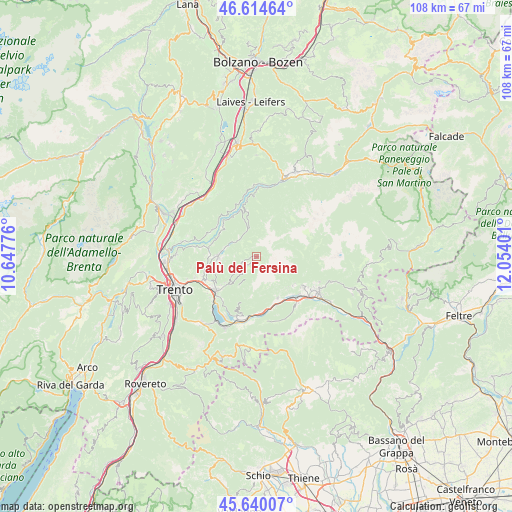
Palù del Fersina GPS coordinates[2]
46° 7' 46.236" North, 11° 21' 3.168" East
| Map corner | latitude | longitude |
|---|---|---|
| Upper-left | 46.61464°, | 10.64776° |
| Center: | 46.12951°, | 11.35088° |
| Lower-right: | 45.64007°, | 12.05401° |
| Map W x H: | 108.4×108.4 km | = 67.4×67.4mi |
| max Lat: | 47.04031° ⇑5.5% North |
| Palù del Fersina: | 46.12951° |
| min Lat: | ⇓94.5% South 35.50142° |
| min Long | Palù del Fersi | max Long |
| 6.69888° | 11.35088° | 18.48682° |
| W 47.5%⇐ | ⇒52.5% E |
Elevation
Elevation of Palù del Fersina is 1335 m = 4380 ft, and this is 1028.3 m = 3374 ft above average elevation for this country.
| Max E: |
2085 m = 6841 ft | 0.8% |
| Palù del Fersina | 1335 m 4380 ft | |
| Avg. | 306.7 m = 1006 ft | |
Min E: |
-4 m = -13 ft | 99.2% |
See also: Italy elevation on elevation.city.
Geographical zone
Palù del Fersina is located in North temperate zone (between Tropic of Cancer and the Arctic Circle). Distance of this North polar circle is 2272.1 km =1411.8 mi to North.| Distance of | km | miles | from Palù del Fersina |
|---|---|---|---|
| North Pole | 4877.9 | 3031 | to North |
| Arctic Circle | 2272.1 | 1411.8 | to North |
| Tropic Cancer | 2523.2 | 1567.8 | to South |
| Equator | 5129.1 | 3187.1 | to South |


Nearby cities:
15 places around Palù del Fersina: (largest is in red/bold)
• Baselga di Pinè
8.1 km =5 mi,  272°
272°
• Canezza
8.1 km =5 mi,  224°
224°
• Centrale
5.1 km =3.2 mi,  313°
313°
• Fierozzo
3.2 km =2 mi,  230°
230°
• Frassilongo
6 km =3.7 mi, 223°
• Lases
10.3 km =6.4 mi,  280°
280°
• Lona-Lases
10.2 km =6.3 mi, 279°
• Miola di Pinè
7.9 km =4.9 mi, 267°
• Rizzolaga-Campolongo
6.5 km =4 mi,  289°
289°
• Roncegno
10 km =6.2 mi,  153°
153°
• Ronchi Valsugana
9.4 km =5.8 mi,  136°
136°
• Sant'Orsola
4.4 km =2.7 mi,  238°
238°
• Sant'Orsola Terme
4.4 km =2.7 mi, 238°
• Segonzano
9.7 km =6 mi, 313°
• Torcegno
9.8 km =6.1 mi,  128°
128°
Sources, notices
• [Note1] Compared only with cities in Italy existing in our database
• [Src1] Map data: © OpenStreetMap contributors (CC-BY-SA)
• [Src2] Other city data from geonames.org with taken over terms of usage.
• [Src3] Geographical zone / Annual Mean Temperature by Robert A. Rohde @ Wikipedia
