Centrale geodata
Centrale (Trentino-Alto Adige) is a seat of a third-order administrative division; located in Italy in Europe/Rome (GMT+2) time zone. With population of 141 people, there are 11308 cities with bigger population in this country. Compared to other cities in Italy, 95.3% of cities are located further ↓South; 53.1% of cities are located further →East and 97.8% of cities have lower elevation than Centrale. Note1
Administrative division(s):
- Level 1: Trentino-Alto Adige
- Level 2: Provincia autonoma di Trento
- Level 3: Bedollo


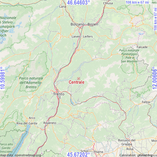
Centrale GPS coordinates[2]
46° 9' 40.248" North, 11° 18' 10.548" East
| Map corner | latitude | longitude |
|---|---|---|
| Upper-left | 46.64603°, | 10.59981° |
| Center: | 46.16118°, | 11.30293° |
| Lower-right: | 45.67202°, | 12.00606° |
| Map W x H: | 108.3×108.3 km | = 67.3×67.3mi |
| max Lat: | 47.04031° ⇑4.7% North |
| Centrale: | 46.16118° |
| min Lat: | ⇓95.3% South 35.50142° |
| min Long | Centrale | max Long |
| 6.69888° | 11.30293° | 18.48682° |
| W 46.9%⇐ | ⇒53.1% E |
Elevation
Elevation of Centrale is 1075 m = 3527 ft, and this is 768.3 m = 2521 ft above average elevation for this country.
| Max E: |
2085 m = 6841 ft | 2.2% |
| Centrale | 1075 m 3527 ft | |
| Avg. | 306.7 m = 1006 ft | |
Min E: |
-4 m = -13 ft | 97.8% |
See also: Italy elevation on elevation.city.
Geographical zone
Centrale is located in North temperate zone (between Tropic of Cancer and the Arctic Circle). Distance of this North polar circle is 2268.5 km =1409.6 mi to North.| Distance of | km | miles | from Centrale |
|---|---|---|---|
| North Pole | 4874.4 | 3028.8 | to North |
| Arctic Circle | 2268.5 | 1409.6 | to North |
| Tropic Cancer | 2526.7 | 1570 | to South |
| Equator | 5132.6 | 3189.2 | to South |


Nearby cities:
15 places around Centrale: (largest is in red/bold)
• Baselga di Pinè
5.4 km =3.4 mi,  233°
233°
• Cembra
6.4 km =4 mi,  283°
283°
• Faver
5.5 km =3.4 mi,  293°
293°
• Fierozzo
5.7 km =3.5 mi,  167°
167°
• Grumes
6.7 km =4.2 mi,  353°
353°
• Lases
6.7 km =4.2 mi,  254°
254°
• Lona-Lases
6.7 km =4.2 mi, 253°
• Miola di Pinè
5.7 km =3.5 mi, 227°
• Palù del Fersina
5.1 km =3.2 mi,  133°
133°
• Rizzolaga-Campolongo
2.7 km =1.7 mi,  240°
240°
• Sant'Orsola
5.8 km =3.6 mi,  180°
180°
• Sant'Orsola Terme
5.8 km =3.6 mi, 180°
• Segonzano
4.6 km =2.9 mi,  314°
314°
• Sover
6.8 km =4.2 mi,  8°
8°
• Valda
5.9 km =3.7 mi,  330°
330°
Sources, notices
• [Note1] Compared only with cities in Italy existing in our database
• [Src1] Map data: © OpenStreetMap contributors (CC-BY-SA)
• [Src2] Other city data from geonames.org with taken over terms of usage.
• [Src3] Geographical zone / Annual Mean Temperature by Robert A. Rohde @ Wikipedia
